Tuesday, December 6, 2016

Aspendos - Roman City near the Mediterranean Coast


http://www.alanyaseaport.com/en/39/13-aspendos
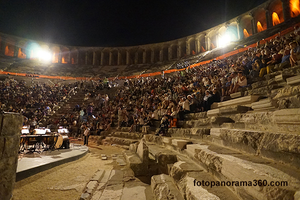
Aspendos is an ancient Roman city located near the Turkish Mediterranean coast about 35 km. east of Antalya. It features one of the best-preserved amphitheaters of antiquity, an acropolis and the remnants of a complex aqueduct system.

The acropolis - the highest part of the city - is located directly behind the amphitheater on a prominent hill. The ruins on the acropolis are close to the theater and can be accessed from the same parking lot on the path seen on the right side of the picture. 

http://fotopanorama360.com/aspendos/
The partially-excavated city complex is surrounded by agricultural fields. The view below looks toward the sea (south).
http://www.ritebook.in/2014/03/aspendos-roman-theater-turkey.html

The theater was built in 155 A.D. by a native of the city, the architect Zenon, during the rule of the Roman Emperor Marcus Aurelius. Consistent with the earlier Hellenistic (Greek) practice, the back side of the theater was built into the hill.
As one of the best-preserved ancient theaters in the ancient world, the Aspendos Theater has a diameter of 96 m. (380 feet), and provided seating for 15,000 people.

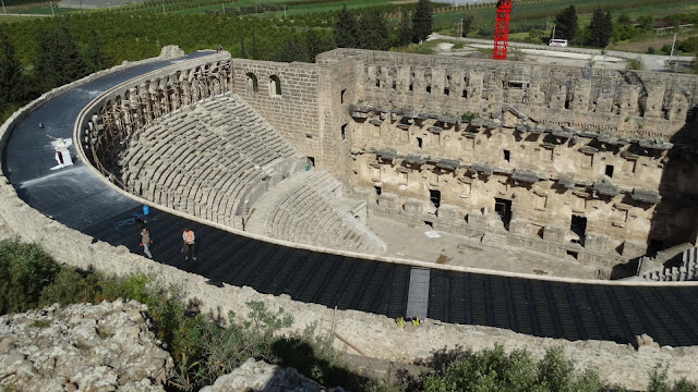
It was being refurbished when I was there in the Summer of 2014, and workers were installing a large roof over the perimeter of the structure. 


Compare the size of the workers walking on the new roof to the main structure - it is huge!

Cliff Emerson©
The sides of the amphitheater were built over vaulted arches. Post holes for 58 masts are found in the upper level of the theater. The masts supported a velarium (leather awning) that could be pulled over the top of the audience to provide shade.
Cliff Emerson©

The high stage served to isolate the audience from the rest of the population. The entire stone backdrop structure has remained intact. An 8-meter-wide wooden ceiling over the stage was used to reflect sound - it has been lost over time. In the 13th century, the Seljuks converted the stage building into a palace.

They repaired the theater from time to time, and also used it as a caravanserai - a place on a traveled path where the camels and caravan party members could stop overnight at a protective environment - and receive rest, water, and food. These are found throughout Turkey and parts of the Middle East. I will feature one in an upcoming post.
https://www.tripadvisor.com.tr/LocationPhotoDirectLink-g297963-d548067-i306099135-Aspendos_Ruins_and_Theater-Serik_Serik_District_Turkish_Mediterranean_Coa.html

Current Use of the Structure
Until recently, the ancient theater was used for concerts, festivals and other public events. Due to damage caused by theatrical and sound equipment, authorities decided to open a new, modern facility nearby and devote the amphitheater strictly to tourism. 

Below, a carved Dionysus figure from a stone gable in the stage structure. 
http://www.theatrum.de/703.html

Above: Aspendos, römisches Theater, Mittelgiebel in der scaenae frons mit Darstellung des aus dem Akanthusbusch wachsenden Dionysos (Photo: G. Krämmer).

Aspendos roman theater, center gable of the scaenae frons with a representation of Dionysios in the midst of the growing Akanthus bush.

For me, Aspendos was a mystical place - an impression I obtained from viewing the aqueduct ruins with a backdrop of curiously-shaped mountains to the west and north - set in a misty environment.

The aqueduct system supplied water to the ancient roman city from spring sources in the neighboring mountains to the west - over a distance of 19 km. This is the best part of the visit. It would have been extremely enjoyable to investigate the entire length of the water channel route beyond the stretch where the aqueduct crossed the valley, but time wouldn't allow, nor did I have adequate documentation or a map.

According to historians, there were two sources of spring water: the Gökçepinar (pleasant spring) at 550 m. elevation, with a discharge of 30-40 liters/sec and the Pinarbas (springhead) at 440 m., with a discharge of 40 liters/sec.

cliff_emerson
Above, a section of the Aspendos Aqueduct, as it curves roughly 50-degrees toward the acropolis hill. The water in the aqueduct came out of the mountains in the background, went through a siphon device to in order to cross the valley, and turned at the height you can see in the picture. It then proceeded across this +100 meter section into the city on the acropolis. (see map, below.)

Also above, in the foreground, huge pieces of concrete from the Roman city have fallen down the hillside and remain lying there.
The path of the lower section of the aqueduct is marked in yellow as it crosses the valley. 

To me, this is the most intriguing part of the Aspendos site. 

I will go into the details of the aqueduct in soon. Click here to connect with another post that discusses the aqueduct system.

cliff_emerson
A village with a mosque and minaret is located next to the aqueduct, looking southwest. In the background, are a few of those strange, mystical hills.

History
Aspendos was an ancient city in the region of Pamphylia, situated on the Eurymedon River, about 16 kilometres inland from the Mediterranean Sea. It had a hostile relationship with a neighboring city, Side (LINK), on the Mediterranean coast.

During the Bronze Age, the Hittites called the city Asitawanda, a place where they traded horses. Like nearby Perge, Aspendos was probably established many years earlier in the Iron Age.

Aspendos was one of the earliest cities to mint coins in the region, first came the "staters" and later, Greek drachmas.

The wide range of its coinage found throughout the ancient world indicates that by the 5th century B.C., Aspendos had become very influential urban center in Pamphylia. 
Aspendos continued to issue coins until the late Roman period.

At that time the nearby Eurymedon River was navigable as far as Aspendos, and the city derived great wealth from a trade in salt, oil, and wool. 

https://www.romeartlover.it/Aspendos.html

An attractive ceremonial arch was built over one of the three streets leading to the upper town. Archaeologists have found a limited number of statues, reliefs and in general marbles in the upper town (acropolis) of Aspendos, unlike the numerous finds at nearby Perge.

In 333 B.C., Aspendos paid a tribute to Alexander the Great to avoid being taken over. It later ignored its agreements with him, and was then occupied. In 190 B.C. the city surrendered to the Romans, who later pillaged its artistic treasures.   
Aspendos went into decline towards the end of the Roman period, which continued throughout the Byzantine times.

Scanned map.
The map above (I found it on-line years ago, but can't site it now), shows the destinations that I pursued with my rental car on that one hurried day: Side (right side), followed by Aspendos, and then Perge. Aspendos is located 48 km. east of Antalya.

Archaeology Insights:
Near the ancient theater stands the remains of several items: a basilica, an agora, a nymphaeum and a Roman aqueduct that extended 15 km. into the mountains. I may cover these in a future post.

The remains of an aqueduct siphon system at Aspendos are matched by another system located in Pergamon (modern Perga), Turkey. More forthcoming in a future blog.

The Roman Eurymedon Bridge, (greatly reconstructed) is also in the vicinity, and will be covered in a future post.


Click here for the Blog's Table of Contents


Friday, April 17, 2015

Tourist Attractions: Nemrut Dağı

Before I get back to my primary focus - western Turkey - I'd like to share photos of a special tourist site in the East.
http://www.roughguides.com/destinations/europe/turkey/things-miss/#/5
Nemrut Dagi (Turkish: Nemrut Dağı; Armenian: Նեմրութ լեռ), would probably be my favorite place to visit. However, due to the war in Syria, and unstable conditions in eastern Turkey, it was not recommended to visit in those days. A Westerner could get kidnapped, or worse. 

I chose to drive north to Hittite country (Hattusha) from my conference in Nevsehir, Cappadocia instead of a couple 100 km. to Nemrut Dağı in the east. YouTube video 9:01
https://www.youtube.com/watch?v=1ZCxBRA66u4

http://whc.unesco.org/uploads/thumbs/site_0448_0004-500-333-20140708161646.jpg
The ruins are located on a cone-shaped mountain. The Ataturk Reservoir on the Euphrates River is visible in the background (and also featured on maps at the end of this post.)


The archaeological site actually consists of two collections of stone heads and rubble on opposite sides of a the hill (elevation: 2,134 m / 7,001 ft) in a very remote area of East-central Turkey.
http://sacredsites.com/images/middle_east/turkey/strange-peak-500.jpg
The complexes - on opposite sides of the mountain - were erected by the ancient Armenian king, Antiochus, head of the Commagene Empire. These statues - along with fragments of bas-relief figures from a frieze - are located near the summit. 
http://www.roughguides.com/destinations/europe/turkey/things-miss/#/7
Damage to the statues indicates that they were intentionally decapitated; the heads now lie scattered throughout the site, and have not been restored to their original positions. Some are turned upright. The figures appear to have Greek-style facial features, but Persian clothing and hair-styling.

Archaeologists have created an historical reconstruction of this first-century BCE complex:  
www.adiyamantb.gov.tr -
A nearby site has a large stone slab with a lion, showing the arrangement of stars and the planets Jupiter, Mercury and Mars on 7 July 62 BC. The site is thought to have used for religious ceremonies based on the astronomical signs caused by alignment of specific figures.
http://www.otelcenneti.com/uploads/il/adiyaman.jpg
The Commagene Empire was a successor state to the Seleucid Empire, defeated by the Romans in 190 BCE at the Battle of Magnesia. LINK 
mhtpcakmak.blogcu.com
This religious site - between the Taurus mountains and the Euphrates - could have been created by Antiochus to unify his multi-ethnic kingdom and secure the authority of his dynasty.
http://whenonearth.net/beheaded-statues-nemrut-dagi-turkey/
Although the Imperial cult did not last long after Antiochus, several of his successors had their own tombs built on Mount Nemrud.
https://www.youtube.com/watch?v=7CG3VL-iRWE
The sites were excavated in 1881 by Karl Sester, a German engineer, who was scouting-out transport routes through the Ottoman Empire. Subsequent excavations have failed to reveal Antiochus' tomb, but he is still believed to be buried here.
http://whc.unesco.org/uploads/thumbs/site_0448_0002-500-333-20140708161645.jpg
Mount Nemrut was made a World Heritage site by UNESCO in 1987.


http://whenonearth.net/beheaded-statues-nemrut-dagi-turkey/
For around half of the year, Mount Nemrud lies covered in snow. Combined with freezing temperatures, this precipitation causes weathering or erosion of the statues.
whenonearth.net
Here's a helpful site map:
www.PlanetWare.com
Below, I've pinpointed the location of Nemrut Dağı, southeast of Malatya.
http://cromwell-intl.com/travel/turkey/pictures/map-physical.jpg
arpacik.net
GOOGLE.maps.com
Map above: Nemrut Dağı National Park, colored in green is near the Ataturk Reservoir on the Euphrates River. It drains to the SW on its way to meeting with the Tigris River in Iraq before pouring into the Persian Gulf.

Additional Information about Nemrut Dağı:
http://nemrud.nl/

Here is a link to the site's Table of Contents:  LINK
To visit other topics on my website, Click here for the Table of Contents

Monday, September 15, 2014

Siege of Constantinople 1453 - Part #1

https://istanbulclues.com/wp-content/uploads/2018/07/Panorama-1453-History-Museum-Istanbul.jpg
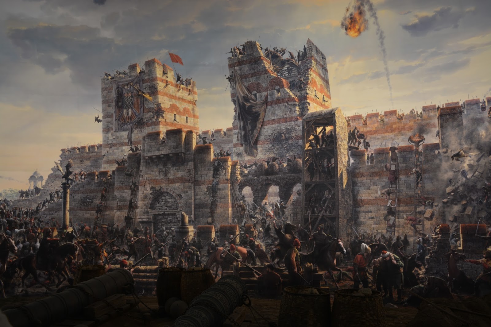
Sultan Mehmed II and his Ottoman army laid siege to the  city of Constantinople on 06 April 1453 and broke through the walls after 53 days. The attackers were commanded by the 21-year-old Sultan who conquered the capital of the Christian Byzantine Empire and converted it into a Muslim caliphate. Most of the city was destroyed after 3 days of looting.

Click here to access a terrific long written rendition of the event on Wikipedia.

The defeat of Emperor Constantine XI Palaeologus marked the defeat of the last critical remnant of the Byzantine Empire, which had survived over 1000 years. 

Click here for the larger, scalable version of this dramatic picture, and click a second time. Notice that you should then be able to use the scroll bars up and down in the expanded view. 

What an horrific struggle!
cliff_emerson
In order to better understand the background of this earth-shaking event, I want to first introduce you to the 1453 Panorama Museum in western Istanbul, located 15 km. from the city center / Sultanahmet - taxi, tram or bus. This museum was built about 200 meters east of the Theodosian Walls where the Ottoman Turks first breached the walls, after the small Kerkoporta Gate was breached about 2-3 km. to the north near the Blachernae Palace.
cliff_emerson©
I took these pictures of the scenes from the 360-degree panorama inside the museum. They show the battle from the perspective of the Ottoman attackers - outside of the walls - looking eastward toward the defending Byzantine armies of Constantinople on the walls.
cliff_emerson
Above, a fiery missile - possibly "Greek Fire" launched by catapults - flies toward the Ottomans.

Below, you can see the irreparable breach made by the Ottomans that allowed them to flood into the city. I believe the event is portrayed "gloriously and heroically" in the painting, compared to actual historical accounts I've read.
Below is a photo of the spectators inside the museum on the viewing platform responding to what they see and hear. Remember, this museum is built "in the round" for 360-degrees.
http://uk.reuters.com/resources/r/?m=02&d=20110530&t=2&i=425041088&w=&fh=&fw=&ll=700&pl=390&r=2011-05-30T115023Z_02_GM1E75U071Y01_RTRRPP_0_TURKEY

I noticed that relatively few Westerners visit the museum, probably because it is not well publicized and is located so far from the city center (Sultanahmet). It also represents a glorious victory over one of the greatest Christian strongholds in the West.

However, I think this stop is imperative for any visitor to the city, as it allows you to see a dramatic, pictorial representation of an event that forever changed the Byzantine Empire from Christian to Moslem. By destroying its capital, Constantinople, and the last vestiges of this great empire, the course of Western Civilization made an abrupt turn.

The door was then opened for the Ottomans to invade the Balkan peninsula, which began immediately thereafter, including the two unsuccessful sieges of Vienna, in 1529 and 1683. Each is a remarkable story.

Click here for the Siege of Vienna 1529.
Click here for the Second Siege of Vienna 1683

It will also help you to understand the story of many Byzantine tourist sites on your visit to the Sultanahmet, including those that have been wholly or partially destroyed (some have disappeared) - the Hagia Sophia, the cisterns, the Hippodrome, the Constantine Palace (literally beneath the Blue Mosque), the Aqueduct of Valens, displays at the Archaeological Museum, among others.

I made the following video inside the 1453 Panorama Museum. Notice the "realia" - implements and objects of war - on the floor next to the viewing platform. Most of these larger pieces are certainly original - that is, they were taken from the battlefield.

The cannon in the video certainly must have been used, as it's cracked. I'm sure these items constituted prized souvenirs to the Ottoman conquerors, and were kept safe from being lost over time. The cannon balls - hewn from solid granite (I'd estimate 60-70 cm. in diameter) - are most probably original. Another cannon, above, is from the siege, as well. It's located in the courtyard at Istanbul's Military Museum, and is worth the visit.

The diameter of the largest cannon used in the attack was over 1 meter! This huge one, and several of the smaller ones were cast by a Hungarian cannon-maker, Urban, at the present-day city of Edirne (Greek: Adrianople). They were then pulled overland 150 miles / 240 km. to Constantinople. A few were reported to have been taken to ships on the shore of the Sea of Marmara before they were off-loaded near Constantinople.


The Ottoman military music you hear in the background of the battle scenes at the 360 Museum is similar to that from the military marching bands you can see at the Topkapi Palace in Istanbul or at the Istanbul Military Museum

Clicking on the YouTube links, above, will give you a quick listen.

The cannon and moulded cannon balls are probably genuine!
http://for91days.com/photos/Istanbul/Panorama%201453%20History%20Museum/Istanbul-Constantinopel.jpg
wikipedia
Above is a terrific map of the Byzantine city of Constantinople before it was conquered. The Theodosian Land Wall - stretching 7 km. on the left, north-to-south - was targeted by Mehmet II, and indeed fell decisively on the last day of the siege.

Click here for a scalable version of this map. Click on it and then use the side scroll bars or mouse wheel to navigate.

I took the following video of the existing Byzantine wall (with a lot of wind in the background) at a site near the 1453 Panorama Museum.

I made this video while traveling north-to-south on a tram that runs parallel to a major freeway and the Byzantine Wall.

A similar view.

This is a picture of the museum's ground floor. Exhibits are all in Turkish. I didn't find them to be very helpful.
http://media-cdn.tripadvisor.com/media/photo-s/03/e9/ab/c1/panorama-1453.jpg
This photo, below, shows the panorama museum from the outside - looking east - toward a stretch of the Byzantine Wall, seen in the background, left.
http://media-cdn.tripadvisor.com/media/photo-s/03/e9/ab/c1/panorama-1453.jpg
Map below: The 1453 Panorama Museum is located at the Topkapi Tram Stop - on the tram line that runs between the airport and Sultanahmet (tourist area). Look inside the left edge of the red square. It is just south of the large Topkapi motorway intersection on this map (marked in green, with black script "Topkapi"):

You've just finished seeing: "Siege of Constantinople 1453 - Part #1" - Sept. 2014
Additional posts forthcoming.

Click here for the Table of Contents" for this website.

Wednesday, May 28, 2014

Flying from Istanbul (IST) to Antalya


http://en.wikipedia.org/wiki/Istanbul_Atat%C3%BCrk_Airport
Istanbul Atatürk Airport (IST) (İstanbul Atatürk Havalimanı) was until recently the main international airport serving Istanbul. It was named after Mustafa Kemal Atatürk (1881-1938), the founder and first president of the Republic of Turkey. I frequently flew through IST between Europe and my home in Muscat, Oman, or to vacation in Turkey. 


http://www.constructionweekonline.com/pictures/Aldar/ataturk-airport.jpg
For you airplane buffs: IST had three runways:
  • 05/23 - pointing to the 1:00 o'clock position. I landed on this runway every time - coming in low over the Sea of Marmara. (See 2nd video below)
  • 18L/36R and 18R/36L - they run parallel, toward the 10 o'clock position. This one was always used for take-off.
The prevailing winds here come mainly from the north.
++++++++++++++
Check-out this video of a beautiful approach over the Sea of Marmara circling in front of the IST airport in order to land 10 minutes later. Expand to full screen for best effect.

This video shows approach to land at IST over the Sea of Marmara. Expand screen for best effect.
http://en.wikipedia.org/wiki/Istanbul_Atat%C3%BCrk_Airport#mediaviewer/File:Turkish_Airlines_Boeing_777-300ER_TC-JJI_IST_2012-11-24.png
IST is located in Yeşilköy, on the Sea of Marmara, 15 miles (24 km) west of the city center.  A second airport (Sabiha Gökçen International Airport), located on the Asian side, also served the greater metropolitan area, which has a total population of 13.2 million.
http://wahyuinqatar.files.wordpress.com/2010/04/istanbul_districts_map.png
This is passenger Arrivals and Departure area of the International Terminal.
http://en.wikipedia.org/wiki/Istanbul_Atat%C3%BCrk_Airport#mediaviewer/File:Ataturk_airport_Istanbul_01589.jpg

A terrorist attack was carried out on this exact spot on the day I was scheduled to arrive and depart here for Berlin - Tuesday, 28 June, 2016. Click here and here (graphic detail).
http://resize.khabarindiatv.com/resize/newbucket/660_-/2016/06/turkey-airport6-1467182390.jpg
Flights in the air were diverted to other airports. My 12:30 am flight out of Oman was kept on the ground and rescheduled for the next day at noon. Everything was cleaned-up by then, as it was Hadj season, and the Turks wanted to have everything back in order.
http://www.cnn.com/2016/06/29/europe/turkey-istanbul-ataturk-airport-attack/

Here's an Airbus 340-300. I flew on one of these many times in- and out of the Middle East for 8 years, especially with Lufthansa flying from Denver to Frankfurt, and then Frankfurt to Dubai/Muscat.


Video: It's common to see Hadj groups passing through the Istanbul airport on their way to Mecca, in this case, in November, 2014. (Click to enlarge.)
The Turks are now  building a larger airport near the Black Sea (Karadeniz):

Turkey awards contract for third Istanbul airport
by Construction Week Online Staff on May 8, 2013 

The existing Ataturk Airport in Istanbul is hemmed in by development and cannot expand.

Turkey began construction on the new Istanbul airport in 2014 with a bid of $29 Billion.
It is set to be the largest airport in the world!

Expected figures for the new airport:
  • 90 million passengers/year anticipated by 2017 (after Phase 1, costing $10 Billion) 
  • 150 million travelers/year (at completion)
  • The country hopes to have one of the top 10 economies of the world (GDP $2 trillion, up from $782 Billion currently). It was 17th in 2019 with $743.
http://www.constructionweekonline.com/article-22306-turkey-awards-contract-for-third-istanbul-airport/

Here are some artist's concept pictures of the new airport, scheduled to be completed in February, 2018.
http://www.spiegel.de/fotostrecke/neuer-istanbuler-flughafen-eine-tulpe-als-kontrollturm-fotostrecke-134725.html


...and an actual aerial photo during construction:
https://pbase.com/dosseman/istanbul_turkey


Below: a view of the Sea of Marmara region looking south-west, over the Black Sea. In the center-left is the Sea of Marmara, which connects to the Black Sea with a narrow channel - the Bosphorus - passing by Istanbul. Beyond are the Aegean Sea and Greek islands.
http://earth.imagico.de/large.php?site=bosporus1

Istanbul is located on the Bosporus close to the Sea of Marmara on the European side.
++++
IST Take-off Video, March 2014 (below): 
I made this video as my Turkish Airlines 737 aircraft climbed out of IST airport and turned east - over Istanbul. I was on a starboard / right side window. You can see the following at:
1:18 - Motorway E5 
2:00 - the Prince Islands (Adalar
2:14 - three bridges over the Golden Horn, and Sultanahmet  
2:50 - the Prince Islands and the Asian side
2:57 - large skyscrapers near Taksim Square and Gezi Park, site of the now-famous riots of 2013-14.
3:10 - Sultanahmet and the Golden Horn

Marked on the map below is the approximate path I flew that day:


Here are five photos I took from the aircraft, looking basically south, as we rose through the mist into the clouds. The two Bridges, Galata (photo) and the Atatürk (photo) link the Sultanahmet to Istanbul's north side, crossing the Golden Horn.
Cliff_Emerson©

Below is panorama of Seraglio Point on the Sultanahmet peninsula. In the distance you can see the Asian side of Istanbul (left) and the mountains of the Prince Islands (right). Intermingled with the trees on the peninsula is the Topkapi Palace complex; right-of-center is the Hagia Sophia, and on the right is the Blue Mosque.
http://static.panoramio.com/photos/large/1027824.jpg

Above: Most of the green area of the peninsula (Sultanahmet) is composed of trees in the foreground, and the Topkapi Palace grounds behind it.

My photo (looking south) below clearly shows all three bodies of water:
  • the Sea of Marmara (upper, middle),
  • Golden Horn (right), and
  • the Bosporus (left).
Cliff_Emerson©
Topkapi Palace Grounds
https://www.islamiclandmarks.com/turkey/topkapi-palace
Cliff_Emerson©

The Bosporus is spanned by the the first Bosporus Bridge (Boğaziçi Köprüsü) (photo). Built in 1973, it is one of the world's longest single-span bridges, at 3,525 feet (1,074 meters).
Cliff_Emerson©
Cargo, military and  tourist cruise ships pass between the Black Sea and Mediterranean Sea through the Bosporus. The Russians must pass through this narrow area to get in and out of the Crimea.
Cliff_Emerson©

Finally, below you can see the E5 Motorway passing over the Bosporus Bridge, as we disappear into the clouds over the Asian side.
Cliff_Emerson
+++++
I flew southward across western Turkey on this tripwith a laminated topographic map in hand (scanned, below) - now prerequisites when I fly over Turkey - you don't want to miss identifying things from the air!

The map came from an old German GEO magazineIt guided me across valleys and mountainous terrain on my way south to the Mediterranean. I've marked an approximate travel route from Istanbul to my destination, Antalya:

GEO Zeitung
In case you need to orient yourself better to Turkey, click on this link for a country-sized geography map.

Here, you see two snow-capped mountains, with a lake, near Isparta.
Cliff_Emerson©
Same mountains and lake - different angle - further to the south.
Cliff_Emerson©

Alexander the Great and his army came through this same territory after crossing the Dardanelles and fighting at the Battle of Granicus, in May 334 BC. 

He went south along the western coast of Turkey (Priene, Bodrum, Ephesus) and then along the southern coast, past modern-day Antalya and Side, and northward - up to the region of Gordion (Gordion's Knot). After going through Ankara, his army went down to meet Darius III in the Battle of Issus, on his way to the Persia, in 334 BCE.

During my descent toward Antalya; the aircraft allowed me to look more closely at features on the ground. The topography is less rugged and arid, with fields and forests, including several clear-cut areas.
Cliff_Emerson©

Paul and Barnabas trekked through this area on their way from the port city of Perga to Antioch in Pisidia [map below, blue line]. Thereafter, they went eastward to the ancient cities of Iconium, Lystra and Derbe, and returned on basically the same route to Attalia [gold line]. (First Missionary Journey: Acts 13:1-14:27, about 46-48 CE)
http://www.teach4god.com/NTS/wp-content/uploads/2013/07/Pauls-First-and-Second-Missionary-Journey.jpeg

Final approach traveling southward to the Antalya Airport. Mountains are replaced by farmland, including a large number of greenhouses. This view looks straight west.
Cliff_Emerson©

This is a view of the Antalya Airport (ATY) from the north - in the direction I landed - toward the Mediterranean Sea.

And below, the view is turned 180-degrees, looking north, toward Istanbul. It's interesting to see how the Duden Waterfalls...
...and the large apartment buildings are basically in the flight path.
 

Finally, looking to the west on this north-bound approach, you can barely see the Bay of Antalya and coastal mountains of the Beydarglari Range through the clouds. On this visit, I visited the archaeological ruins of Termessos, located in these mountains.
http://www.jo-igele.de/flug-stgt-antalya-mit-tuifly-das-geht-besser/
Additional entries on this website:
Click here to go back to my first Web entry for Side: "Visit to Side #1"
Click here for:  "Paul's First Journey - Part 2: Traveling from Cyprus to Southern Turkey"
Click here for:  "Siege of Constantinople 1453 - Part #1"


Click here for the Blog's Table of Contents

Featured Post

Hittites in Turkey #3 - Bogazköy

  wikipedia Hittite cuneiform tablets from Bogazköy  https://www.hethport.uni-wuerzburg.de/HPM/hpm-en.php?p=general-en The only existing col...