Monday, September 15, 2014

Siege of Constantinople 1453 - Part #1

https://istanbulclues.com/wp-content/uploads/2018/07/Panorama-1453-History-Museum-Istanbul.jpg
Sultan Mehmed II and his Ottoman army laid siege to the  city of Constantinople on 06 April 1453 and broke through the walls after 53 days. The attackers were commanded by the 21-year-old Sultan who conquered the capital of the Christian Byzantine Empire and converted it into a Muslim caliphate. Most of the city was destroyed after 3 days of looting.

Click here to access a terrific long written rendition of the event on Wikipedia.

The defeat of Emperor Constantine XI Palaeologus marked the defeat of the last critical remnant of the Byzantine Empire, which had survived over 1000 years. 

Click here for the larger, scalable version of this dramatic picture, and click a second time. Notice that you should then be able to use the scroll bars up and down in the expanded view. 

What an horrific struggle!
cliff_emerson
In order to better understand the background of this earth-shaking event, I want to first introduce you to the 1453 Panorama Museum in western Istanbul, located 15 km. from the city center / Sultanahmet - taxi, tram or bus. This museum was built about 200 meters east of the Theodosian Walls where the Ottoman Turks first breached the walls, after the small Kerkoporta Gate was breached about 2-3 km. to the north near the Blachernae Palace.
cliff_emerson©
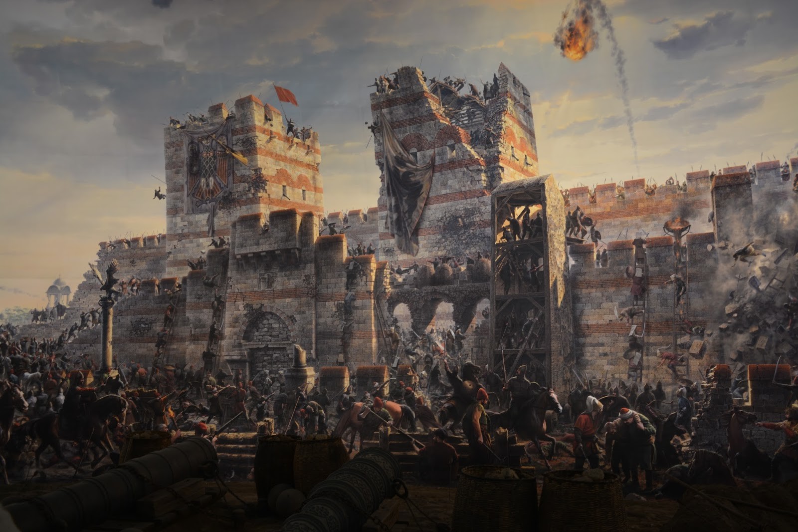
I took these pictures of the scenes from the 360-degree panorama inside the museum. They show the battle from the perspective of the Ottoman attackers - outside of the walls - looking eastward toward the defending Byzantine armies of Constantinople on the walls.
cliff_emerson
Above, a fiery missile - possibly "Greek Fire" launched by catapults - flies toward the Ottomans.

Below, you can see the irreparable breach made by the Ottomans that allowed them to flood into the city. I believe the event is portrayed "gloriously and heroically" in the painting, compared to actual historical accounts I've read.
Below is a photo of the spectators inside the museum on the viewing platform responding to what they see and hear. Remember, this museum is built "in the round" for 360-degrees.
http://uk.reuters.com/resources/r/?m=02&d=20110530&t=2&i=425041088&w=&fh=&fw=&ll=700&pl=390&r=2011-05-30T115023Z_02_GM1E75U071Y01_RTRRPP_0_TURKEY

I noticed that relatively few Westerners visit the museum, probably because it is not well publicized and is located so far from the city center (Sultanahmet). It also represents a glorious victory over one of the greatest Christian strongholds in the West.

However, I think this stop is imperative for any visitor to the city, as it allows you to see a dramatic, pictorial representation of an event that forever changed the Byzantine Empire from Christian to Moslem. By destroying its capital, Constantinople, and the last vestiges of this great empire, the course of Western Civilization made an abrupt turn.

The door was then opened for the Ottomans to invade the Balkan peninsula, which began immediately thereafter, including the two unsuccessful sieges of Vienna, in 1529 and 1683. Each is a remarkable story.

Click here for the Siege of Vienna 1529.
Click here for the Second Siege of Vienna 1683

It will also help you to understand the story of many Byzantine tourist sites on your visit to the Sultanahmet, including those that have been wholly or partially destroyed (some have disappeared) - the Hagia Sophia, the cisterns, the Hippodrome, the Constantine Palace (literally beneath the Blue Mosque), the Aqueduct of Valens, displays at the Archaeological Museum, among others.

I made the following video inside the 1453 Panorama Museum. Notice the "realia" - implements and objects of war - on the floor next to the viewing platform. Most of these larger pieces are certainly original - that is, they were taken from the battlefield.

The cannon in the video certainly must have been used, as it's cracked. I'm sure these items constituted prized souvenirs to the Ottoman conquerors, and were kept safe from being lost over time. The cannon balls - hewn from solid granite (I'd estimate 60-70 cm. in diameter) - are most probably original. Another cannon, above, is from the siege, as well. It's located in the courtyard at Istanbul's Military Museum, and is worth the visit.

The diameter of the largest cannon used in the attack was over 1 meter! This huge one, and several of the smaller ones were cast by a Hungarian cannon-maker, Urban, at the present-day city of Edirne (Greek: Adrianople). They were then pulled overland 150 miles / 240 km. to Constantinople. A few were reported to have been taken to ships on the shore of the Sea of Marmara before they were off-loaded near Constantinople.


The Ottoman military music you hear in the background of the battle scenes at the 360 Museum is similar to that from the military marching bands you can see at the Topkapi Palace in Istanbul or at the Istanbul Military Museum

Clicking on the YouTube links, above, will give you a quick listen.

The cannon and moulded cannon balls are probably genuine!
http://for91days.com/photos/Istanbul/Panorama%201453%20History%20Museum/Istanbul-Constantinopel.jpg
wikipedia
Above is a terrific map of the Byzantine city of Constantinople before it was conquered. The Theodosian Land Wall - stretching 7 km. on the left, north-to-south - was targeted by Mehmet II, and indeed fell decisively on the last day of the siege.

Click here for a scalable version of this map. Click on it and then use the side scroll bars or mouse wheel to navigate.

I took the following video of the existing Byzantine wall (with a lot of wind in the background) at a site near the 1453 Panorama Museum.

I made this video while traveling north-to-south on a tram that runs parallel to a major freeway and the Byzantine Wall.

A similar view.

This is a picture of the museum's ground floor. Exhibits are all in Turkish. I didn't find them to be very helpful.
http://media-cdn.tripadvisor.com/media/photo-s/03/e9/ab/c1/panorama-1453.jpg
This photo, below, shows the panorama museum from the outside - looking east - toward a stretch of the Byzantine Wall, seen in the background, left.
http://media-cdn.tripadvisor.com/media/photo-s/03/e9/ab/c1/panorama-1453.jpg
Map below: The 1453 Panorama Museum is located at the Topkapi Tram Stop - on the tram line that runs between the airport and Sultanahmet (tourist area). Look inside the left edge of the red square. It is just south of the large Topkapi motorway intersection on this map (marked in green, with black script "Topkapi"):

You've just finished seeing: "Siege of Constantinople 1453 - Part #1" - Sept. 2014
Additional posts forthcoming.

Click here for the Table of Contents" for this website.

Wednesday, May 28, 2014

Flying from Istanbul (IST) to Antalya


http://en.wikipedia.org/wiki/Istanbul_Atat%C3%BCrk_Airport
Istanbul Atatürk Airport (IST) (İstanbul Atatürk Havalimanı) was until recently the main international airport serving Istanbul. It was named after Mustafa Kemal Atatürk (1881-1938), the founder and first president of the Republic of Turkey. I frequently flew through IST between Europe and my home in Muscat, Oman, or to vacation in Turkey. 


http://www.constructionweekonline.com/pictures/Aldar/ataturk-airport.jpg
For you airplane buffs: IST had three runways:
  • 05/23 - pointing to the 1:00 o'clock position. I landed on this runway every time - coming in low over the Sea of Marmara. (See 2nd video below)
  • 18L/36R and 18R/36L - they run parallel, toward the 10 o'clock position. This one was always used for take-off.
The prevailing winds here come mainly from the north.
++++++++++++++
Check-out this video of a beautiful approach over the Sea of Marmara circling in front of the IST airport in order to land 10 minutes later. Expand to full screen for best effect.

This video shows approach to land at IST over the Sea of Marmara. Expand screen for best effect.
http://en.wikipedia.org/wiki/Istanbul_Atat%C3%BCrk_Airport#mediaviewer/File:Turkish_Airlines_Boeing_777-300ER_TC-JJI_IST_2012-11-24.png
IST is located in Yeşilköy, on the Sea of Marmara, 15 miles (24 km) west of the city center.  A second airport (Sabiha Gökçen International Airport), located on the Asian side, also served the greater metropolitan area, which has a total population of 13.2 million.
http://wahyuinqatar.files.wordpress.com/2010/04/istanbul_districts_map.png
This is passenger Arrivals and Departure area of the International Terminal.
http://en.wikipedia.org/wiki/Istanbul_Atat%C3%BCrk_Airport#mediaviewer/File:Ataturk_airport_Istanbul_01589.jpg

A terrorist attack was carried out on this exact spot on the day I was scheduled to arrive and depart here for Berlin - Tuesday, 28 June, 2016. Click here and here (graphic detail).
http://resize.khabarindiatv.com/resize/newbucket/660_-/2016/06/turkey-airport6-1467182390.jpg
Flights in the air were diverted to other airports. My 12:30 am flight out of Oman was kept on the ground and rescheduled for the next day at noon. Everything was cleaned-up by then, as it was Hadj season, and the Turks wanted to have everything back in order.
http://www.cnn.com/2016/06/29/europe/turkey-istanbul-ataturk-airport-attack/

Here's an Airbus 340-300. I flew on one of these many times in- and out of the Middle East for 8 years, especially with Lufthansa flying from Denver to Frankfurt, and then Frankfurt to Dubai/Muscat.


Video: It's common to see Hadj groups passing through the Istanbul airport on their way to Mecca, in this case, in November, 2014. (Click to enlarge.)
The Turks are now  building a larger airport near the Black Sea (Karadeniz):

Turkey awards contract for third Istanbul airport
by Construction Week Online Staff on May 8, 2013 

The existing Ataturk Airport in Istanbul is hemmed in by development and cannot expand.

Turkey began construction on the new Istanbul airport in 2014 with a bid of $29 Billion.
It is set to be the largest airport in the world!

Expected figures for the new airport:
  • 90 million passengers/year anticipated by 2017 (after Phase 1, costing $10 Billion) 
  • 150 million travelers/year (at completion)
  • The country hopes to have one of the top 10 economies of the world (GDP $2 trillion, up from $782 Billion currently). It was 17th in 2019 with $743.
http://www.constructionweekonline.com/article-22306-turkey-awards-contract-for-third-istanbul-airport/

Here are some artist's concept pictures of the new airport, scheduled to be completed in February, 2018.
http://www.spiegel.de/fotostrecke/neuer-istanbuler-flughafen-eine-tulpe-als-kontrollturm-fotostrecke-134725.html


...and an actual aerial photo during construction:
https://pbase.com/dosseman/istanbul_turkey


Below: a view of the Sea of Marmara region looking south-west, over the Black Sea. In the center-left is the Sea of Marmara, which connects to the Black Sea with a narrow channel - the Bosphorus - passing by Istanbul. Beyond are the Aegean Sea and Greek islands.
http://earth.imagico.de/large.php?site=bosporus1

Istanbul is located on the Bosporus close to the Sea of Marmara on the European side.
++++
IST Take-off Video, March 2014 (below): 
I made this video as my Turkish Airlines 737 aircraft climbed out of IST airport and turned east - over Istanbul. I was on a starboard / right side window. You can see the following at:
1:18 - Motorway E5 
2:00 - the Prince Islands (Adalar
2:14 - three bridges over the Golden Horn, and Sultanahmet  
2:50 - the Prince Islands and the Asian side
2:57 - large skyscrapers near Taksim Square and Gezi Park, site of the now-famous riots of 2013-14.
3:10 - Sultanahmet and the Golden Horn

Marked on the map below is the approximate path I flew that day:


Here are five photos I took from the aircraft, looking basically south, as we rose through the mist into the clouds. The two Bridges, Galata (photo) and the Atatürk (photo) link the Sultanahmet to Istanbul's north side, crossing the Golden Horn.
Cliff_Emerson©

Below is panorama of Seraglio Point on the Sultanahmet peninsula. In the distance you can see the Asian side of Istanbul (left) and the mountains of the Prince Islands (right). Intermingled with the trees on the peninsula is the Topkapi Palace complex; right-of-center is the Hagia Sophia, and on the right is the Blue Mosque.
http://static.panoramio.com/photos/large/1027824.jpg

Above: Most of the green area of the peninsula (Sultanahmet) is composed of trees in the foreground, and the Topkapi Palace grounds behind it.

My photo (looking south) below clearly shows all three bodies of water:
  • the Sea of Marmara (upper, middle),
  • Golden Horn (right), and
  • the Bosporus (left).
Cliff_Emerson©
Topkapi Palace Grounds
https://www.islamiclandmarks.com/turkey/topkapi-palace
Cliff_Emerson©

The Bosporus is spanned by the the first Bosporus Bridge (Boğaziçi Köprüsü) (photo). Built in 1973, it is one of the world's longest single-span bridges, at 3,525 feet (1,074 meters).
Cliff_Emerson©
Cargo, military and  tourist cruise ships pass between the Black Sea and Mediterranean Sea through the Bosporus. The Russians must pass through this narrow area to get in and out of the Crimea.
Cliff_Emerson©

Finally, below you can see the E5 Motorway passing over the Bosporus Bridge, as we disappear into the clouds over the Asian side.
Cliff_Emerson
+++++
I flew southward across western Turkey on this tripwith a laminated topographic map in hand (scanned, below) - now prerequisites when I fly over Turkey - you don't want to miss identifying things from the air!

The map came from an old German GEO magazineIt guided me across valleys and mountainous terrain on my way south to the Mediterranean. I've marked an approximate travel route from Istanbul to my destination, Antalya:

GEO Zeitung
In case you need to orient yourself better to Turkey, click on this link for a country-sized geography map.

Here, you see two snow-capped mountains, with a lake, near Isparta.
Cliff_Emerson©
Same mountains and lake - different angle - further to the south.
Cliff_Emerson©

Alexander the Great and his army came through this same territory after crossing the Dardanelles and fighting at the Battle of Granicus, in May 334 BC. 

He went south along the western coast of Turkey (Priene, Bodrum, Ephesus) and then along the southern coast, past modern-day Antalya and Side, and northward - up to the region of Gordion (Gordion's Knot). After going through Ankara, his army went down to meet Darius III in the Battle of Issus, on his way to the Persia, in 334 BCE.

During my descent toward Antalya; the aircraft allowed me to look more closely at features on the ground. The topography is less rugged and arid, with fields and forests, including several clear-cut areas.
Cliff_Emerson©

Paul and Barnabas trekked through this area on their way from the port city of Perga to Antioch in Pisidia [map below, blue line]. Thereafter, they went eastward to the ancient cities of Iconium, Lystra and Derbe, and returned on basically the same route to Attalia [gold line]. (First Missionary Journey: Acts 13:1-14:27, about 46-48 CE)
http://www.teach4god.com/NTS/wp-content/uploads/2013/07/Pauls-First-and-Second-Missionary-Journey.jpeg

Final approach traveling southward to the Antalya Airport. Mountains are replaced by farmland, including a large number of greenhouses. This view looks straight west.
Cliff_Emerson©

This is a view of the Antalya Airport (ATY) from the north - in the direction I landed - toward the Mediterranean Sea.

And below, the view is turned 180-degrees, looking north, toward Istanbul. It's interesting to see how the Duden Waterfalls...
...and the large apartment buildings are basically in the flight path.
 

Finally, looking to the west on this north-bound approach, you can barely see the Bay of Antalya and coastal mountains of the Beydarglari Range through the clouds. On this visit, I visited the archaeological ruins of Termessos, located in these mountains.
http://www.jo-igele.de/flug-stgt-antalya-mit-tuifly-das-geht-besser/
Additional entries on this website:
Click here to go back to my first Web entry for Side: "Visit to Side #1"
Click here for:  "Paul's First Journey - Part 2: Traveling from Cyprus to Southern Turkey"
Click here for:  "Siege of Constantinople 1453 - Part #1"


Click here for the Blog's Table of Contents

Sunday, April 27, 2014

Didyma - Ancient City of Oracles and Sacred Way

Didyma, (Δίδυμα) is the name of an ancient Greek temple complex on Turkey's west coast which served as an important site for the delivering of oracles. What is an oracle? I'll explain that below.
https://blogger.googleusercontent.com/img/b/R29vZ2xl/AVvXsEjgl-bBxESSWwv3HeBGgfSO_jccyw3MQhGcqqMkclZpzRdAoufa3Q3Alj9nugKFkRDcXlsizh7iW8mJ4kWxFu7BxLBP6k0qTSBxhknDBq5qBsXvsi_jVwO4KZ5bKD7LWxNT7Yn3odNkv0I/s1600/fsafasfasf.jpg
Visiting Didyma was a strange experience for me... a place hard to describe... mystical, confounding and overwhelming to the senses. 
Cliff_Emerson
Compared to similar sites I have visited in Greece, Turkey, and Italy (especially Paestum), this temple seems to be the most intriguing and difficult to "get my head around." Two primary  reasons: "How could these fluted stone columns be so unbelievably huge?" "Who were these people, and what were they performing here?"
http://test.classconnection.s3.amazonaws.com/628/flashcards/23628/jpg/temple-of-apollo.jpg
#1.) First, how did they produce these enormous columns  Compare the size of the people to the column bases in the following pictures.
Cliff_Emerson
Cliff_Emerson

#2.) In addition, how did they create the fabulous, well-preserved ornamentation on the columns?
Cliff_Emerson

cliff_emerson
Cliff_Emerson
Cliff_Emerson
Keep in mind: these artifacts are very old - built by the Greeks, and not Romans. They date back to roughly 300 BCE - about 2300 years!

Didyma was one of the most important sites for oracles in the ancient Greek world, and was also the 4th largest sanctuary or temple in size. It centered on the oracle of Apollo. The most famous oracle site is Delphi, in central Greece.
https://sacredsites.com/middle_east/turkey/oracle_of_apollo_didyma.html

The complex measured 168 x 385 ft. (51 x 109 m) and had a 120 columns that were 65 ft. (19.7 m.) high. Unfortunately, almost all of them are knocked down today.

Each Spring visitors would first make a 10 mile / 17 km. pilgrimage along a paved road - the Sacred Way from Miletus to Didyma. While walking this route, the pilgrims stopped at ritual way-stations and pondered statues of animals and humans, some which date back to the 6th century BCE. (Click here to see several figures in the British Museum.) None of these seem to be available for viewing at the Turkish site - they were presumably taken from Didyma to England by archeologists.
Map: In the bottom, right corner you see the location of Miletus and Didyma (red dots). The Sacred Way ran between them and is not easy to locate today.

Definition:
In Greek Antiquity, an oracle was the name of a site or person where one could receive wise counsel, prophecy or predictions, as inspired and delivered by the gods. Oracles were thought to be portals through which the gods spoke to people.

The word oracle comes from the Latin verb ōrāre "to speak" and refers to a priest or priestess who uttered the requested answer or prediction (khrēsmoi, χρησμοί). Oracles were held in such high regard that leaders and influential people from countries beyond Greece often sought such counsel.

This was similar to consulting a seer (manteis, μάντεις) who interpreted signs sent by the gods through bird signs, animal entrails, and many other means. They, too, could see things hidden from normal mortals, and had the ability to predict the future and speak for the gods.
Cliff_Emerson_C
The ancient site of Didyma is famous from legendary times. Here was a natural spring where the beautiful Leto is supposed to have spent an hour of love with Zeus, then giving birth to the twins Artemis and Apollo (didymoi).

It is the most important oracle site in Asia Minor (modern Turkey). Pronouncements were received there by Croesus, Alexander the Great and other great kings who altered the course of human history.
cliff_emerson
From its earliest beginnings, Didyma was a pre-Greek cult sanctuary centered around a sacred grove and holy spring from the 8th - 7th centuries BC.

The sanctuary of Apollo consists of a walled enclosure measuring approximately 24 x 10 m, an open-air sanctuary, a portico 16 m in length, a sacred well and a votive altar.
Cliff Emerson
Above: Within the sanctuary complex, this rectangular area 175 ft. x 70 ft. (53.5 m. x 21.5 m.), with walls originally 72 ft.  (22 m. high) housed the actual Temple of Apollo 47 ft. x 27 ft. (14.2 m. x 8.2 m.).

It was built over the small foundation in the background, and contained a statue of Apollo and the sacred spring. Here the priestess received revelations that were interpreted by a priest and then were communicated back to those who had come to consult the oracle.
Cliff Emerson
Above: Looking in the opposite direction, one sees the steps used by the priests to bring the pilgrim's' requests down into the central courtyard of the temple (cella). Two doorways on either side also lead into this courtyard.

Following is a diagram that portrays the likely structure of the sanctuary.

http://sites.davidson.edu/csa/wp-content/uploads/2013/04/apollo-temple-didyma-sailing-map.png
By the 7th century BCE, the Ionian Greeks had adopted the site, dedicated it to the worship of Apollo. Thereafter, the fame of its oracle spread across the eastern Mediterranean and into Egypt.

As mentioned earlier, the most famous site for Greek oracles was at Delphi, north of Corinth (see it on the map, below).

(Use the horizontal scroll bar to also see the location of Didyma over in modern-day Turkey.)
https://figures.boundless.com/13647/full/-20of-20greek-20santuaries.jpe
Map: Principal Religious Sanctuaries of the Greek Aegean. This is the heartland of Ancient Greece - territory on both sides of the Aegean Sea.. Before reading on, please do note of both locations for Didymes (Didyma), and Delphi. (Here's a link to Delphi in Wikipedia.)

 NOTE: The most famous Roman site to visit on Turkey's Aegean coast, Ephesus, lies just north of Didyma. It may be possible to find a bus tour that takes you from Ephesus to Didyma.

The following video focuses on the huge assortment of stones lying around the temple site, plus a row of columns, and one (of the three) standing columns:
The temple was located approximately 17 kilometers south of the city of Miletus, inland from the small port of Panormos. In the Archaic period, when the first temple of Apollo was constructed, a Sacred Way, lined with sculptures, sarcophagi and statues of lions and sphinxes, led from Panormos to the sanctuary. Pilgrims arriving by sea would disembark at the port of Panormos [or Miletus] and walk the Sacred Way to the oracle of Apollo.
http://sacredsites.com/middle_east/turkey/oracle_of_apollo_didyma.html
Background:
  • "494 BCE - The Persians destroyed a second and larger temple at the same site while it was still under construction.
  • 5th - 4th centuries BCE - Little is known about activities at Didyma and it seems to have suffered a decline.
  • 334 BCE - After his capture of the city of Miletus, Alexander the Great placed the administration of the oracle in the hands of the city.
  • 331 BCE - The sanctuary of the oracle was revived when the sacred spring was rediscovered on the occasion of a visit from Alexander (during which time the oracle proclaimed him “the son of Zeus”).

Cliff_Emerson
  • "In the following decades  - Seleucus embellished the sanctuary and commissioned the new Hellenistic Temple of Apollo (about 300 BC a cult statue of Apollo that had been stolen by the Persians was returned to Didyma).
  •  For the next 200 years - The sanctuary grew in fame, attracting thousands of pilgrims from throughout the Hellenistic world, and work on the temple continued.
  • This temple, measuring 51 by 110 meters, was the third largest structure of the Greek world, exceeded only by those at Ephesus and Samos (Greek island).
  • Although the Hellenistic (i.e. Greek) Didymaion was of greater dimensions than the archaic temple, it was merely an adaptation of the original plan. The massive temple had a total of 124 columns (many of which were never erected) and was embellished with the most wonderful sculptures of Greek artistry. One particularly enormous column weighs 70 tons.
Cliff Emerson
  • "In 278 BCE - the sanctuary suffered under the raids of Gauls, but construction work on the temple was resumed.
  • In 70 BCE - pirates sacked the sanctuary, and work on the temple was terminated. The sanctuary, however, continued to function. 
  • In 100 CE. Trajan commissioned a new paved road to the sanctuary from Miletus.
  • By the 3rd century CE Christianity had become well established in the Miletus area and the sanctuary at Didyma fell gradually into disuse.
  • In 262 CE the Apollonian Oracle temple (which had never been completed, despite five centuries of service), was converted into a fortress against invading Goths (Germanic tribes from the North and East) and Saracens (seafaring Arabic Muslims link).
  • In 385 CE, the famous oracle was officially closed by an edict of Theodosius, and a Byzantine church was erected within the temple compound. The buildings were ravaged by fire.
  • In the 15th c. CE a great earthquake reduced the temple to rubble, toppling all but three of its towering columns.

The video (above) highlights a young visitor beside a huge column, some carved stone detail, and one of the two tunnel entrances to the sacred temple area.

"The French first began excavations at the Temple of Apollo in 1834, followed by the Berlin Museum from 1904 to 1913, and then by the German Archaeological Institute from 1962 until the present.

"What exactly stimulated the oracular and visionary insights experienced by the temple priests is not currently known but geologists assume it had something to do with the temple’s location at a place of geologic activity and its construction directly upon an active spring. Recent geological studies at the oracle of Delphi have confirmed that vision-inducing vapors did indeed rise from fissures beneath its Apollonian temple yet similar studies have thus far not been conducted at the shrine of Didyma."

"The way in which the Apollonian oracles communicated their pronouncements is also not clear from either legendary or historical sources. It seems probable that, similar to Delphi in Greece, there were those who received the oracular messages and those who then interpreted those messages to the supplicants and pilgrims visiting the temple. It is clear that male priests were concerned with the communication of the prophetic messages, but whether males or only females were the prophets (like at Delphi) is not currently known."

Source of the above text: http://sacredsites.com/middle_east/turkey/oracle_of_apollo_didyma.html

Here are pictures of the Sacred Way leading north to Miletus.
http://media-cdn.tripadvisor.com/media/photo-s/03/a2/6d/b1/miletus.jpg
According to historian Mark Wilson in Biblical Turkey: A Guide to the Jewish and Christian Sites of Asia Minor (Amazon: book), the 13 - 23 ft (4 - 7 m.) wide road dates as early as 700 BCE, and was resurfaced 4 times - the latest time in 100-101 CE.
Cliff_Emerson
Below: German archaeologists put up a sign near the sanctuary with a map which I captured with my camera. I've highlighted the Sacred Way (Heilige Strasse) in yellow. Note that it intersects and is covered by a paved road on the north side the Apollo Heiligtum (sanctuary), which is hemmed-in by a number of residential buildings. 
Cliff_Emerson
Also note that the Artemis Temple (on the left side of the Sacred Way) lies largely un-excavated and inaccessible.
Cliff_Emerson
This head of Medusa (
3 ft. / 0.9 m.) was found on-site. In Greek mythology Medusa ("guardian, protectress") was a monster, a Gorgon, with the face of a hideous woman with living venomous snakes instead of hair. Gazing directly into her eyes would turn onlookers to stone. Medusa was beheaded by the hero Perseus, who thereafter used her head as a weapon before he gave it to the goddess Athena to place on her shield. In classical antiquity the image of the head of Medusa was an apotropaic symbol - used to ward off evil. [This reminds me of the "evil eye" images that you see for sale as souvenirs across Greece and along the Aegean Sea in Turkey!]
Cliff Emerson
This video begins with a view of the south side of the complex, then focuses on the extremely tight, rectilinear stonework of the wall, and closes with stones scattered around the site. Below, look at the tight fit - using no morter!


Written Greek inscription on a stone - Maybe someday I'll be able to read some of it.
http://cdn4.vtourist.com/4/6232866-The_supports_for_the_column_pieces_still_in_place_Didyma.jpg?version=2
A fallen column on the back side of the sanctuary is a "must see" when you visit Didyma

Also, if you have time, scroll all the way back to the first picture of this post in order to see it from an aerial perspective.

Finally, on one side of the temple are the scattered remnants of several capitals with griffins on them. I found these rather curious, so I did a short study on the topic in an attempt to figure-out what they were doing at Didyma.
The griffin (Greek: γρύφων, Latin: gryphus) is a legendary creature made from
  • a lion's body, tail, and back legs, and 
  • an eagle's head, wings and talons on the front feet.
Because the lion was traditionally considered the king of the beasts, and the eagle the king of birds, the griffin was thought to be an especially powerful and majestic creature - the king of all creatures.  In antiquity it was a symbol of divine power and guardian of divine or priceless treasures.
The earliest depictions of griffins are the 15th c. BCE frescoes in the Throne Room of the Bronze Age Palace of Knossos, Crete (link). They continued as a favored decorative theme in Archaic and Classical Greek art, and may have come through this means to Didyma.

There is also evidence of griffins in Ancient Persian and Egyptian art as far back as 3,300 BCE, though found in different anatomical configurations.  In Central Asia the griffin appears about a thousand years after Bronze Age Crete (5th–4th c. BCE), probably originating from the Achaemenid Persian Empire as a protector from evil, witchcraft and secret slander.
One theory proposes that the griffin was an ancient misconception derived from the fossilized remains of the Protoceratops dinosaur (picture) found in gold mines in the Altai mountains of Scythia, in Kazakhstan, or in Mongolia. (German Wikipedia article)
In medieval heraldry (sample), the griffin is an amalgamation of lion and eagle was a symbol of military courage, strength and leadership.
It's still unclear to me how these figures were used at Didyma, and when they were created. After looking at the accompanying leaf design (previous photo) and comparing it to other designs on-site, it bears the mastery of Greek arcticians.

Outside Links:
Holy Land Photos - Temple of Apollo
Sacred Sites - Places of Peace and Power

Featured Post

Hittites in Turkey #2 - Yazilikaya

Yazilikaya - Holy sanctuary at  the Hittite capital of Hattuša Yazilikaya (m eaning 'inscribed rock' in Turkish), is an  ancient Hit...