The only existing collection that provides information about the history of the civilization of the Hittites was unearthed at Bogazköy (ancient site also called Hattusas), located near Ankara, in central Turkey. These tablets also give us information about the history of Asia Minor and the Middle East.
Here's a close-up shot of the cuneiform tablet above:
Although the Hittites were one of the most powerful ethnic groups in the Middle East during the 2nd millennium B.C., they were completely unknown to scholars and archeologists up until the mid-nineteenth century, except through the Old Testament. These individuals scoffed at the existence of Hittite culture, language and civilization.The first inkling that they might actually have existed came in 1894 when linguist William Wright discovered that the script on a monument at Bogazköy was similar to inscriptions found at Aleppo and Hamath in Northern Syria. (page 335)
The collection contains around 25.000 tablets, including the records of social, political, commercial, military, religious, legislative and artistic aspects of life.
The archive includes tablets of Treaty of Quadesh signed between Hittites and Egypt. This well-known treaty of "eternal peace" guaranteed peace and security throughout the area.
Artist uses Artificial Intelligence to recreate the face of Alexander the Great
Dutch photographer and digital designer Bas Uterwijk uses artificial intelligence (AI) to generate hyper-realistic images of famous historical figures. LINK
Uterwijk has a background in computer graphics, 3D animation, and special effects. Here is his professional website: WEBSITE
Here's more information about virtual recreation:
Many of us who have studied Art History or the History of Western Civilization may be acquainted with Alexander's image from the Alexander Mosaic, displayed today in the painting, The Alexander Mosaic,
...which depicts the Battle of Issus between Alexander the Great (356-323 BC) and Darius III (d.330 BC) in 333 BC. This was fought on what is today Turkish soil. We'll look at it in more detail in an upcoming blog entry.
The Roman floor mosaic with this fighting scene was removed from the House of the Faun (Casa del Fauno) LINK, an imposing 2nd c. residence in Pompeii, Italy covered by the eruption of Mt. Vesuvius. The mosaic is now housed in the National Archaeological Museum, Naples, Italy.
Here's what wikipedia has to say about the painting:
The Alexander Mosaic is a Roman floor mosaic originally from the House of the Faun in Pompeii (an alleged imitation of a Philoxenus of Eretria or Apelles' painting, 4th century BC) that dates from c. 100 BC.[1] It is typically dated in the second half of the century between 120 and 100 B.C.[2] It depicts a battle between the armies of Alexander the Great and Darius III of Persia and measures 2.72 by 5.13 metres (8 ft 11 in × 16 ft 10 in).[3] This work of art is a combination of different artistic traditions such as Italic, Hellenistic, and Roman. The mosaic is considered “Roman” based on the broader context of its time and location in relation to the later Roman Republic.[2] The original is preserved in the Naples National Archaeological Museum.
It depicts a battle scene between the armies of Alexander the Great and Darius III of Persia.
https://en.wikipedia.org/wiki/Achaemenid_Assyria
Darius III is on the verge of being killed or captured!
Background;
For more than two centuries, the Achaemenid Empire of Persia ruled the Mediterranean world. One of history’s first true super powers, the Persian Empire stretched from the borders of India down through Egypt and up to the northern borders of Greece.
https://en.wikipedia.org/wiki/Achaemenid_Assyria
The Persian Empire's rule was brought to an end by the brilliant military and political strategist Alexander the Great.
Alexander III was born in 356 B.C. in the small Greek-speaking Kingdom of Macedonia, located in northern Italy. Tutored in his youth by Aristotle and trained for battle by his father, Philip II, Alexander the Great grew to become a powerful imperialist. His undermanned defeat of the Persian King Darius III at the Battle of Gaugamela is seen as one of the decisive turning points of human history, unseating the Persians as the greatest power in the ancient world and spreading Hellenistic culture across a vast new empire.
Alexander owed a tremendous debt to his father for leaving him a world-class army led by experienced and loyal generals. But it was Alexander’s genius as a leader and battlefield strategist that secured his victory against an imposing adversary deep in enemy territory.
Philip II Left a legacy of a Fierce fighting Army to his son
Macedonian Army developed by Philip II
The Macedonian Phalanx, a rectangular infantry formation, was developed by Philip II of Macedon and used by his son Alexander the Great to conquer other armies.
The Macedonians weren’t always a force to be reckoned with. The historic centers of Greek power were the city-states of Athens, Sparta and Thebes to the south, whose leaders regarded the Macedonians as barbarians. It was Alexander’s father, Philip, who single-handedly transformed the Macedonian army into one of the most feared fighting machines in the ancient world.
Philip reorganized all of Macedonian society around a professional army and raised elite fighting forces of infantry, cavalry, javelin throwers and archers. Aristocratic young men would start their military training at seven years old and graduate to officers at 18. The highest positions were in the Royal Companion Cavalry, the king’s own personal squadron, and in the Royal Hypaspists, an elite 500-man infantry unit that surrounded the king in battle.
Weaponry also got an upgrade under Philip. Gone was the shorter “dory” or Greek wooden spear (7 feet long), and in its place was the much longer sarissa, an 18- to 22-foot hunting spear with an iron tip that could puncture heavy armor and impale charging cavalry horses.
Backed by his shiny new army, Philip marched south in 338 B.C. and defeated an all-star alliance of Athens and Thebes at the Battle of Chaeronea. The battle served as a coming-out party for 18-year-old Alexander, who bravely led the Macedonian cavalry charge that broke through the Athenian ranks and secured victory for the upstart kingdom.
With the Greek mainland subdued under Macedonian rule, Philip turned his well-oiled army East toward the Persian Empire, a far greater prize. But soon after crossing the Hellespont into Persian territory, Philip was assassinated, making young Alexander the new king and commander-in-chief of the Macedonian forces.
“As soon as Alexander came to the throne, he openly stated that he would carry on his father’s plans,” says Graham Wrightson, a history professor at South Dakota State University and author of Combined Arms Warfare in Ancient Greece. But before Alexander could push into Persia, he had to take care of business back home.
The Greek city-states of Athens and Thebes weren’t thrilled to be under the thumb of “barbarian” kings, particularly since it infringed on their democratic ideals. Immediately after Alexander was made king, Thebes rose up to challenge his authority—a big mistake. Not only did the Macedonian army easily crush the Thebian rebellion, says Wrightson, “but Alexander razed Thebes to the ground and sold the entire city into slavery, except for one house owned by the descendants of his favorite poet.”
Always the savvy strategist, Alexander knew that he couldn’t rule the Greek mainland by fear and brute force alone. So as he turned his attention back to Persia, Alexander framed his campaign against the Achaemenid Empire as a patriotic retaliation for Persia’s failed invasion of the Greek mainland a century earlier. That conflict featured the famous Battle of Thermopylae, where 300 Spartan warriors made a heroic last stand against tens of thousands of Persian invaders.
“Alexander creates a propaganda campaign that the Macedonians are invading Persia on behalf of the Greeks, even though Macedon wasn’t part of Greece and didn’t fight on the side of Greece in the original Greco-Persian wars,” says Wrightson. “He’s invading Persia to punish the Persians retroactively for daring to invade Greece in the first place.”
Whether motivated by Greek pride or the spoils of imperial conquest, Alexander picked up where his father left off and marched into Persia in 334 BC, where his army of 50,000 would be tested against the largest and best-trained fighting force in the known world.
It’s estimated that King Darius III of Persia was in command of a total of 2.5 million soldiers spread across his vast empire. At the heart of the Persian army were the “Immortals,” an elite regiment of 10,000 infantrymen whose numbers never changed. When a man was killed, another rose to take his place. The Persian cavalry and archers were also legendary, as were the scythe chariots which cut down enemy infantry with their razor-sharp wheel hubs.
But there were also signs that the Persian Empire was already in decline. After suffering humiliating back-to-back defeats in Greece in the 5th-century B.C., Persia stopped expanding. In the century leading up to Alexander’s reign, Persia was furthered weakened by a civil war and other internal rebellions. Darius still commanded a massive army, but Persia was receding on the world stage while Macedon had the momentum of an ascendant military super power.
After quickly dispatching a small regional army near the town of Granicus, Alexander had his first real test against Darius and his Persian Royal Army near the coastal city of Issus. Darius’ strategy was to cut off Alexander’s supply lines from behind and force the Macedonian troops to turn around and face off. But Darius botched the location of the battle, which ended up being a narrow strip of land between a ridge and the sea that neutralized his numbers advantage.
At Issus, Alexander debuted the battle strategy that would assure him victory after victory during his remarkable reign of conquest. Knowing he would be outmatched in manpower, Alexander relied on speed and distraction. He would draw enemy troops toward one flank, then wait for a momentary gap to open up in the center of the enemy lines for a head-first cavalry charge.
Just as he did with his father at Chaeronea, Alexander personally led the Macedonian cavalry charge at Issus, which cut right to the heart of the Persian defenses, just as planned. A stunned Darius reportedly hopped on his horse and fled, with the rest of his army close behind.
The two armies wouldn’t meet again for another two years. In the interim, Darius regrouped and called in reinforcements from the East, while Alexander marched his army South into Egypt. When Alexander returned to Persia from his Egyptian conquests, Darius tried to delay the inevitable clash as long as possible, eventually deciding that if there was going to be a rematch, it would be on Daruis’ terms.
Darius and his generals chose a battle site near the town of Gaugamela. It was a wide, flat valley that, unlike Issus, would allow the Persians to take full advantage of their lopsided numbers, an estimated 250,000 Persian troops facing off against Alexander’s 50,000.
“Darius even flattened the ground so that his scythe chariots could charge at the Macedonians,” says Wrightson.
But Alexander will not be outplayed. He camped the Macedonian army in the hills above the battle site to fuel up and rest while he drew up a game plan. The Persians, fearing a night attack, remained in ready formation all night, anxiously awaiting a charge that never came.
At dawn, the Macedonians took the battlefield. True to his strategy, Alexander’s army advanced in a line with the two flanks drawn back like a bow. Then he ordered the entire Macedonian line to march quickly to the right.
Darius, fearing he was about to be overlapped on his left side, sent in 5,000 of his best cavalry. Alexander counter-struck with a regiment of 1,500 mercenaries tasked with holding the right-hand position. Darius grew frustrated with the lack of progress, so he sent in another 10,000 cavalry, almost his entire left flank. Alexander responded with what’s known as his “pawn sacrifice” of several thousand troops destined to die as a set up for the final move.
At this point, Darius ordered a full-frontal charge on the rest of the Macedonian army, but it took time for his orders to reach his left flank. This created just enough slack in the Persian line for Alexander to strike.
“Just as Darius begins the charge, the Macedonians launch a devastating cavalry attack that goes right into the gap cunningly created by Alexander’s tactics,” says Wrightson.
As Alexander and his elite Royal Companion Cavalry raced into the heart of the Persian defenses, they were momentarily surrounded by the enemy, but the experienced Macedonian sarissa regiments fought their way through. According to legend, Alexander killed Darius’ chariot driver and almost captured the Persian king before he fled once again on horseback.
Days later, with Alexander’s cavalry in hot pursuit, Darius was killed by his own cousin, who delivered the fallen king’s head to Alexander as a tribute. Appalled by the treasonous act, Alexander had the man tortured and executed before declaring himself the undisputed king of Macedonia, Greece, and now Persia.
The reign of Alexander the Great was short-lived. After conquering the entire Persian Empire, his army marched east and got as far as India before turning back home to Macedon. His part of the army got as far as Babylon, the place where he determined to build his capital. At just 32 years old, Alexander died in Persia in the palace of Nebuchadnezzar II in Babylon from a sudden and mysterious illness.
Yazilikaya - Holy sanctuary at the Hittite capital of Hattuša
Yazilikaya (meaning 'inscribed rock' in Turkish), is an ancient Hittite sanctuary, situated in some low-lying hills next to the small town of Bogazkale about 170 kilometers east of Ankara. It's an open air shrine nestled in some rocks where a spring of fresh water once flowed - perhaps a place of worship for hundreds or thousands of years before the Hittites rose to power.
The region of Bogazkale had been settled during Paleolithic times but the first real evidence of occupation dates from the first half of the 3rd millennium BC. From old Assyrian texts and from a later, Hittite, document it is known that a city called Hattush was founded around 1900 BC by the Hati culture.
Around the 17th century BC, the Hittites descended from the north and overcame the indigenous Hati people, probably incorporating much of that culture into their own. They conquered the city of Hattush, renaming it Hattusha, and made it the capital of their own empire. The Hittites rapidly became a major power, rivaling Mesopotamia and Egypt. We know from objects of trade, treaties and clay tablet records of their letters that they had contact with Mycenae, Troy and dynastic Egypt. Hattusha remained the capital of the Hittite empire until its mysterious decline around 1200 BC.
It was not until 1909 when archaeologists discovered the city of Hattusha, and its library with thousands of clay tablets, that it was possible to trace these lost people. Excavations of their city revealed a large and powerful culture that was ruled by written laws, had created palaces and fortifications, enjoyed a fixed monetary system, and had developed a religion with its own gods and goddesses. The Hittites were polytheist and together with their own gods and goddesses they also worshipped deities deriving from other Mesopotamian cultures. Records of Hattusili, the first Hittite king who resided at Hattusha, tell of temples dedicated to a sun goddess called Arianna and her daughter Mezulla as well as a weather god named Teshub.
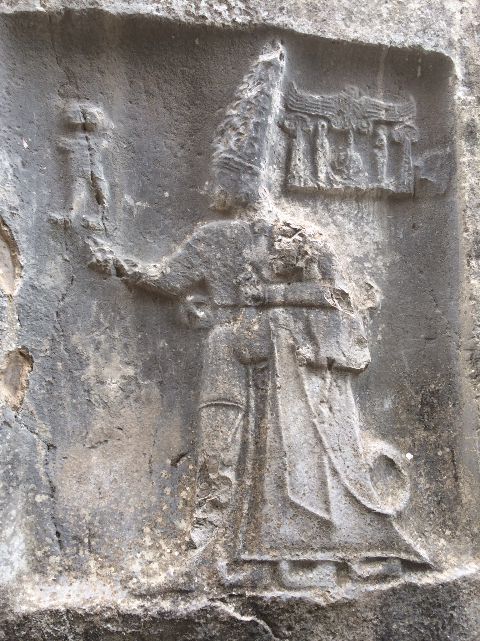
Here are all 12 gods, including the first one (right side) which is covered with a dark, soluble substance that flowed across it from the rock over time.
Above is a view of the chamber where this carving and several others are located.
Yazılıkaya is located in north-central Turkey, north-east of the capital city, Ankara.
The shrine was built more than 3000 years ago.
Historians suggest that the elite of the Hittite society, an empire that dominated what is now central and south-central Turkey between 1700 and 1100 BC until it was destroyed, created the Yazılıkaya shrine to embody their ideas about how the universe was organized.
“There are many connotations with the names of the deities and the arrangements and groups, and so in retrospect it’s pretty easy to figure it out,” says Eberhard Zangger, president of Luwian Studies, an international non-profit foundation. “But we worked on it for seven years
The most impressive area is Chamber A, which contains rock-cut relief of 64 deities in procession. The left wall shows a procession of male deities, wearing the traditional kilts, pointed shoes and horned hats. Mountain gods are also shown with scaled skirts to symbolise the rocky mountains. The right wall shows a procession of female deities wearing crowns and long skirts. The only exception to this divide is the goddess of love and war, Shaushka (Mesopotamian goddess Ishtar/Inanna) who is shown on the male procession with two female attendants. This is likely to be because of her male attributes as the goddess of war.
The processions lead to a central scene of the supreme couple of the pantheon: the storm-god Teshub and the sun-goddess Hebat. Teshub stands on two mountain gods whilst Hebat stands on a panther. Behind Hebat are shown their son Sharruma, daughter Alanzu and a granddaughter.
The smaller and narrower Chamber B has fewer but larger and better preserved reliefs. It may have served as a mortuary mausoleum or memorial for the Hittite king Tudhaliya IV.
The Hittite practise of assimilating other cultures' gods into their own pantheon is in evidence at Yazilikaya. The Mesopotamian god of wisdom, Ea (Enki) is shown in the male procession and the god Teshub was a Hurrian god who was syncretized with the Hittite storm-god. Hebat's original consort was changed into her and Teshub's son (Sharruma) and she was later syncretized with the Hattic Sun goddess of Arinna. It is believed that Puduhepa, who was the daughter of a Hurrian priestess and the wife of the Hittite king Hattusili III, also played a role in the increasing Hurrian influence on the Hittite religion.
A 2021 study concluded that the sanctuary depicted the cosmos including its three levels: earth, sky, and underworld; in addition to the cyclical processes: day/night, lunar phases, and summer/winter, which served as a lunisolar calendar. However, the supreme deities in Chamber A, referred to the northern stars, while Chamber B represented the netherworld.
I saw this peculiar structure in the middle of a desert in a small village while driving from the airport at Nevsehir to Konya in south-central Turkey. I was in the early stages of making a large 2-day circuit with my rental car before attending a professional conference, visiting several cities which the Apostle Paul had visited.
Viewing it from from a distance, I decided to make a short visit and investigate. It wasn't exactly a fortress nor a castle. Instead, it was an inn with stone walls, a caravanserai,(caer-a-van'-ser-ei). These complexes had served a very special function in parts of the world where there had been ancient trade routes.
Example of a small camel caravan in the Libyan desert, Dromedaries, Camelus dromedarius, Akakus mountains, Libya, Sahara, North Africa
Caravanserais are large fortified structures that housed and protected traveling merchants, their caravan animals and their camel drivers who traversed the Silk Road in previous centuries of the Middle Ages, assisting travelers who were navigating routes between China, Turkey and the Mediterranean region.
Map of the routes of the Silk Road.
The caravanserai provided food, shelter, water, and provisions for travelers and their animals. Cool in the summers, and warmth in the winters.
And, perhaps most importantly, they provided security from marauding bands of warriors and thieves who would gladly hurt the people and steal the possessions that were being transported.
Can you imagine trying to spend countless nights in the hostile world of the desert on a journey lasting several months with your camel train? Dangers would come in the form of enemy armies, robbers, wild animals, dust storms, incessant wind, hot and cold temperatures, rain and snow, lack of water and food.
You would really be thankful for the services of a caravanseri - a "full-services motel" to provide overnight lodging.
They also provided an opportunity for merchants and other travelers to exchange goods, access local markets and interact with people from different cultures across the vast stretches of the Silk Road.
https://www.youtube.com/watch?v=JSucjTybSfk
By offering such an intercultural environment, caravanserai were important sites for the exchange of cultural values, languages and ideas. Marco Polo was the most famous traveler to use the Silk Roads.
Anatolia - the area of modern Turkey - has served as a bridge between the East Asia and Western Europe sinceancient times. During the Middle Ages, a large number of roads used by the Silk Road stretched between numerous cities; from Central Asia to Antalya, to the Aegean coast the ports of Ephesus and Miletus, the ports of Trabzon and Sinop in the Black Sea Region, Istanbul in the north-central region, and the Mediterranean ports of Alanya and Antalya in the south. Sea routes were often part of the main route used to reach Europe.
Sultanhani is located on the road between Aksaray and Konya
A detailed listing of Caravanserai in Turkey:
The Silk Road in Anatolia:
In the North: Trabzon, Gümüşhane, Erzurum, Sivas, Tokat, Amasya, Kastamonu, Adapazarı, Izmit, Istanbul and Edirne;
In the South: Mardin, Diyarbakır, Adıyaman, Malatya, Kahramanmaraş, Kayseri, Nevşehir, Aksaray, Konya, Isparta, Denizli, Antalya are the centers passed by.
In general, the following sites in Turkey also have Seljuk caravanserais: Erzurum, Malatya, Kayseri, Ankara, Bilecik, Bursa, İznik, İzmit, and İstanbul.
In order to promote commercial trade in Anatolia, Seljuks provided security by building caravanserais on roads connecting these cities..
Following are some pictures that I took - along with one from another visitor - at the Sultanhani Caravanserai.
cliff_emerson
Front door archway - ornate carved rock.
cliff_emerson
Ornamentation
cliff_emerson
Mithrab - used for praying toward Mecca
cliff_emerson
Individual stall for the caravan
cliff_emerson
Decorated arches
cliff_emerson
Hallway - you can imagine venders selling their goods along the way


