A visit to Alahan Monastery in south-central Turkey
https://commons.wikimedia.org/wiki/Category:Alahan_Monastery?uselang=de#/media/File:Ta%C5%9Feli-Plateau_12_05_1989_Alahan-Kloster.jpg
Alahan Monastery is a complex of fifth century buildings nestled in the Taurus Mountains in south, central Turkey (Mersin province in modern day Turkey). Located at an altitude of 4,000 ft, the complex stands 3,000 ft over the Calycadnus valley. Although termed a monastery in many sources, this attribution is contested, and more recent scholarship consider it to be a pilgrimage shrine. The complex played a significant role in the development of early Byzantine architecture.
This remarkable monastery, built between the 5th-7th century, is perched high on a hillside between the cities of Karaman and Mut, in south-central Turkey, an hour from the Mediterranean Sea.
https://slowtravelguide.com/alahan-monastery-mersin/
The monastery is quite remote and requires a lot of determination on the part of the traveler to reach. There are no famous touristic sites nearby, and thus, it is "way off the beaten path" in terms of where buses on tours usually travel. It was my impression that very few tour groups visit here as I climbed around on the site for at least one hour before seeing other people visiting the site in the month of October.
The monument in the picture above (facing west) is not in its original position (in situ) next to the footpath, but nevertheless adds to the dramatic effect.
(Wikipedia)
The small red dot marks the location of Alahan.As stated earlier, Alahan most likely served as a monastery and pilgrimage site since the early 5th century. One interesting fact about its location is that it is lies just south of a line between the New Testament cities of Lystra and Derbe, cities first visited by Paul and Barnabas in the First Missionary Journey and mentioned in Acts 13.
Alahan and the nearby city of Karaman lie roughly above the "H" in the word "PAMPHILIA" in the map, below.
The city of Karaman, 25 km. directly to the north of Alahan, likely had a Roman Road running through town that connected these cities and was used by the apostles in their travels.
Clarification of the site map, above: Chronology of the Apostles Paul and Barnabas' travel on Roman Roads (dashed lines): After leaving Cyprus and sailing NW to Perga (10 km. east of Antalya), they traveled from to Antioch of Pisidia (not on these maps) and then Iconium (Konya), then to Lystra and finally Derbe. You can see how the road connected through Karaman. Follow the light purple line, and please notice that I've marked the critical cities with a star.
At Derbe - the end of their First Journey - they turned around and reversed the route on their way back to the coastal city of Attalia before sailing for Syria and the home church at Antioch of Syria.
Here's the Biblical account:
The Return to Antioch in Syria - Acts 14:21-28
"21 They preached the gospel in that city and won a large number of disciples. Then they returned to Lystra, Iconium and Antioch, 22 strengthening the disciples and encouraging them to remain true to the faith. “We must go through many hardships to enter the kingdom of God,” they said.
23 Paul and Barnabas appointed elders for them in each church and, with prayer and fasting, committed them to the Lord, in whom they had put their trust. 24 After going through Pisidia, they came into Pamphylia, 25 and when they had preached the word in Perga, they went down to Attalia.
26 From Attalia they sailed back to Antioch, where they had been committed to the grace of God for the work they had now completed. 27 On arriving there, they gathered the church together and reported all that God had done through them and how he had opened a door of faith to the Gentiles. 28 And they stayed there a long time with the disciples."
Alahan is located about 1 hour by car south of Karaman. The apostles had no obvious reason to specifically go there. They merely passed nearby on their way between their two targeted cities - Lystra and Derbe - on a Roman road.
Nevertheless, it would be an eerie feeling in subsequent centuries to live in such close proximity in this entire region, knowing that Paul had journeyed through your town or nearby - that the Biblical cities of Iconium, Lystra and Derbe were there "right in your backyard."
The monastery's location amidst the pine-forested slopes of the Taurus Mountains gives one an "out-in-the-middle-of-nowhere" feeling today. During the Byzantine period (roughly 395 to 1453 AD), the monastery was on a vital north-south trade route that led from central Anatolia (Turkey) south to Claudiopolis (today's Mut) and 25 km beyond to the Mediterranean coast - following the valley bottom, right along the river.
Archaeologists believe Alahan was probably one of Turkey's most important religious centers in the region during the 5th and 6th centuries.
At an altitude of 4,000 feet (1,500 meters), Alahan commands a view westward down 3,000 feet to the valley's river, which flows south to the Mediterranean Sea.
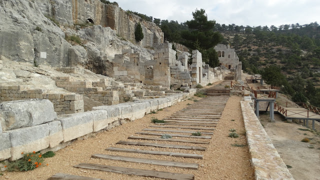
The complex spreads longitudinally on a steep hillside over a large area of about 25 meters wide x 250 meters long. It consists of the Western Church (the Evangelist Basilica), a Monastery and the Eastern Church. Below, the view looking toward the east.
Monastery rooms were carved into the rock.
Cliff_Emerson©
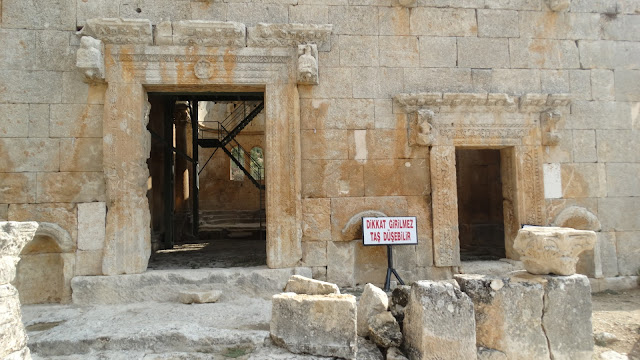
Ornamental gateway.
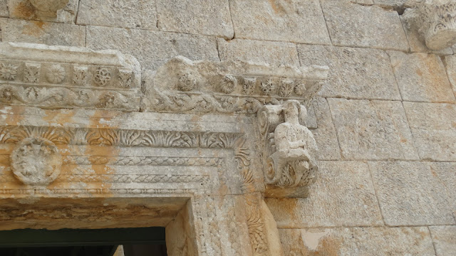
Gateway header.
The complex's rich decorations show that skillful stone masons were available during this period.
The Eastern Basilica has been preserved and is now partially restored, whereas the Western Basilica was largely destroyed, possibly during Arab invasions in the 7th century.
https://commons.wikimedia.org/wiki/Category:Alahan_Monastery?uselang=de#/media/File:MERS%C4%B0N-MUT-ALAHAN_EK%C4%B0M_2011_-_panoramio_(5).jpg
Cliff_Emerson©
View looking east along the walkway toward the East Basilica.
I took the following video shortly after arriving on the site.
Cliff_Emerson
The beautifully preserved East Basilica (pictured below) was completed in the early 6th century. It's the most impressive structure in the entire complex. Keep in mind, this church is enormously old when compared to ecclesiastical buildings in Western Europe. For example, the Gothic age began in a northern suburb of Paris just before 1140. LINK
We'll now spend some time looking at this individual structure.
https://slowtravelguide.com/alahan-monastery-mersin/
https://gezimanya.com/mersin/gezilecek-yerler/alahan-manastiri East Basilica (Koca Kalesi) - above, view from the hillside; illustration below
 |
https://slowtravelguide.com/alahan-monastery-mersin/
|
Interior of the East ChurchCliff_Emerson©
Reinforcing steel beams and girders stabilize the church.
Cliff_Emerson©
Cliff_Emerson©
Cliff_Emerson©
Above, the exterior of the south wall of the East Church.
Below, the west facade of the East Church.Cliff_Emerson©
Here's a small number of ornamental stone carvings that originally belonged to the building.
Cliff_Emerson©
The complex is said to have played a role as an example for early Byzantine architecture for other buildings the Byzantine Empire, and possibly has architectural roots going back to the Armenian style. A recent discovery of 13th and 14th c. Armenian coins on the site indicates that the complex was later occupied in the Medieval period.
Cliff_Emerson©
Above, a stone mason chiseled a cross into this rock.
Cliff_Emerson©Above, an inscription in Greek, language of the Byzantines.
https://slowtravelguide.com/alahan-monastery-mersin/ Below, diagram of entire complex.

I especially enjoyed the views from the monastery down into the bowels of the valley: misty, deep and mysterious.
Cliff_Emerson©
Cliff_Emerson©
Cliff_Emerson©
Cliff_Emerson©
Below, the baptistry in the shape of a Maltese cross, located in the aisle of the West Church, with stairs that converge from four directions.
https://slowtravelguide.com/alahan-monastery-mersin/©
Cliff_Emerson©
While looking down into the valley, I kept thinking of Friedrich Barbarosa, Emperor of the Holy Roman Empire, who led his army down this valley as it was heading for the Holy Land in 1190 in the Third Crusade. [I have an MA in German and have studied Medieval German / European history for many years, so it's no wonder my musing was distracted.] So, now we're going to make a small excursion into this event...
Barbarossa and his troops were on a North-South march heading for Konya (Iconium) and then Karaman (Laranda), and finally down in the valley below Alahan on the way to the Mediterranean shore.
Emperor Frederick Barbarossa tragically drowned 10. June 1190 about 40 km. downstream from Alahan.
This event is a poignant dramatic example of "where East meets West." The Western Crusaders were on their way to free Jerusalem and the Holy Land from their enemies who had overrun it after the death of Mohammed in 632 AD. They encountered fierce opposition from the neighboring enemies to the north. It's ironic and tragic that Frederick Barbarossa met his end in such a "non-combative" event.
As one story about the incident goes, he slipped from his horse in full armor, could not regain his feet, and his vassals could not reach him in time.
There are several other conflicting accounts of the event:
- According to "Ansbert",a Frankish monk, abbot and Bishop of Rouen, the emperor, against everyone's advice, chose to swim across the river and was swept away by the current.
- Another account recorded that Frederick was thrown from his horse while crossing the river, weighed down by his armor, and drowned.
- According to the chronicler Ibn al-Athir, "the king went down to the river to wash himself and was drowned at a place where the water was not even up to his waist. Thus God saved us from the evil of such a man". [the words of a Arab writer]
- The writer of the Letter on the Sacred Expedition of the Emperor Frederick I, a churchman who accompanied the crusader forces, reported that "after the many and terrible exertions that Frederick I had undergone in the previous month and more, he decided to bathe in that same river, for he wanted to cool down with a swim.
A memorial near the river marks the spot of the accident.
 |
| https://www.google.com/maps/place/Friedrich+Barbarossa+An%C4%B1t%C4%B1/@36.3999462,33.8660967,3a,75y,90t/data=!3m8!1e2!3m6!1sAF1QipP_NNK5eDHcxZhaKQAdb-wll4lrrrQm7l-N386G!2e10!3e12!6shttps:%2F%2Flh5.googleusercontent.com%2Fp%2FAF1QipP_NNK5eDHcxZhaKQAdb-wll4lrrrQm7l-N386G%3Dw203-h270-k-no!7i2448!8i3264!4m8!1m2!2m1!1sG%C3%B6ksu+barbarosa!3m4!1s0x14d8e1834170ae01:0xc78862a6b85cd9b4!8m2!3d36.3999728!4d33.8660929?hl=de |
See this 20-second video showing the river in the vicinity of where he drowned: Göksu River
A stone memorial that was erected nearby, with an inscription in Turkish and German. I can't read Turkish and the German is damaged and somewhat hard to decipher:
>>Unweit dieser Stelle ertrank am 10. Juni 1190 der Römisch-Deutsche Kaiser Friedrich 1. Barbarosa im Göksu (Fluß) an der Spitze seines Herres auf dem Wege nach Palastina...<<
The German above, translated:
>>Not far from this spot, Fredrich 1. Barbarosa, Holy Roman Emperor, drowned on 10. June 1190 in the Göksu River while leading his army on its way to Palestine.<<
This is quite rugged territory. The river emerges from the Taurus Mountains and flows across the flatter plane at the base of the Taurus Mountains and in front of the city of Silifke.
https://commons.wikimedia.org/wiki/Category:Alahan_Monastery?uselang=de#/media/File:MERS%C4%B0N-MUT-ALAHAN_EK%C4%B0M_2011_-_panoramio_(5).jpg
Note the red pin mark (map above) in the upper, left corner of the screenshot that pinpoint the spot where Barbarossa drowned.Two two blue markers (below) show a close-up.
It was an enormous tragedy for the expedition, and soon led to its breakup; the entire group became distraught and disorganized and was thereafter continuously attacked by enemy troops from the surrounding countryside. Some of the fortunate crusaders were able to fight their way 35 km. to the coastline, and then journeyed on to the Holy Land by ship. Others returned to Europe.
In succeeding centuries, Friedrich continued to be a mythological figure in German history.
https://www.medievaltymes.com/courtyard/third_crusade.htm
Above map: "x" marks the spot where Friedrich Barbarossa died. The red line shows that the Third Crusade originated at Regenburg.
According to Wikipedia:
Frederick's death caused several thousand German soldiers to leave the scattered force and return home through the Cilician and Syrian ports on the Mediterranean Sea. The German-Hungarian army was struck with an onset of disease near Antioch, weakening it further. Only 5,000 soldiers - less than one third of the original force - actually arrived in Acre (i.e. the Holy Land).
Barbarossa's son, Frederick VI of Swabia, carried on with the remnants of the German army, along with the Hungarian army under the command of Prince Géza, and attempted to bury the emperor in Jerusalem. But, their efforts to preserve his body in barrel filled with vinegar failed.
Therefore, his flesh was interred in the Church of St Peter in Antioch, his bones in the cathedral of Tyre, and his heart and inner organs in Saint Paul's Church, Tarsus. (I'm not sure where these components are today! A bit of research is needed.)
The unexpected demise of Frederick left the Crusader army under the command of the two rivals Philip II and Richard the Lionhearted, who then traveled to Palestine separately by sea.
Richard continued to the East where he fought Saladin, winning territories along the shores of Palestine, but ultimately failed to re-conquer Jerusalem before he was forced to return to his own territories in north-western Europe.
He came home after agreeing that Jerusalem would remain under Muslim control while allowing unarmed Christian pilgrims and traders to visit the city. Thus, they had failed to take the city back from the Muslims who had originally conquered the city in 636-637 AD, a few years after the death of Mohammed. Wikipedia Link
https://www.ancient-origins.net/ancient-places/kyffhausen-castle-0010999
Kyffhäusen Castle, Germany: "When the Ravens Vanish, Barbarossa Will Return"
The medieval Kyffhäuser Castle and the 19th century Monument were built on the Kyffhäuser range in the former East Germany, 30 km. southeast of the Harz Mountains.
 |
| https://www.etsy.com/listing/954932708/high-detailed-germany-physical-map-high?gpla=1&gao=1&&utm_source=google&utm_medium=cpc&utm_campaign=shopping_us_e-home_and_living-home_decor-wall_decor-wall_hangings-other&utm_custom1=_k_Cj0KCQiA7oyNBhDiARIsADtGRZbKRMhdcQ4AQ5035cCF9XxAUaAqglQE8SS6Ha7dhr370YQTQAZiSKUaAnhCEALw_wcB_k_&utm_content=go_12559942210_123094360961_506897962482_pla-305562556206_c__954932708_388441698&utm_custom2=12559942210&gclid=Cj0KCQiA7oyNBhDiARIsADtGRZbKRMhdcQ4AQ5035cCF9XxAUaAqglQE8SS6Ha7dhr370YQTQAZiSKUaAnhCEALw_wcB |
Kyffhäuser Castle is located in the German state of Thuringia, south of Erfurt (red dot). I visited that site a few years ago, but didn't see any signs of Barbarossa!
It is the legendary resting place of Emperor Frederick Barbarossa in German mythology. According to the story, he awakes every 100 years. If he sees ravens, then he will be allowed to come out of his sleep.
 |
| https://www.ancient-origins.net/ancient-places/kyffhausen-castle-0010999 |
Today the Kyffhäuser complex is an open-air museum and a popular tourist destination.
More information about the Kyffhausen Castle in German in this LINK More information here (in German):
Kaiser Barbarossa - Wie Barbarossa in den Kyffhäuser kam | MDR DOK (42 minutes)
https://www.youtube.com/watch?v=Mrf-0Y2Kc54&t=205s
++++++
Now, back to our study of Alahan... below is picture taken by an aerial drone, looking north. The East Church is located on the extreme right side.
https://www.basyaylahaber.com/haber-alahan-manastiri-36740.html

Cliff_Emerson©
Apsis of the second church.
Most likely a burial crypt
The site of the first church structure built, and later possible places made into lodging for the monks.
Note the images carved into the rocks, below.
Cliff_Emerson
Angel
Cliff_Emerson©
Cliff_Emerson©
Alahan Monastery is on the list of sites currently nominated for World Heritage status.
In closing, here's a Turkish YouTube consisting of some video cuts and still shots, if you have time to watch (5 min. 32 sec.): (Be sure to turn the music down!)
Cliff_Emerson©
Click here for a return to the Blog Table of Contents


No comments:
Post a Comment