Friday, January 6, 2017

Visit to Side #1

What an incredible Roman city! I had a great visit here.
Wikipedia

The ancient city of Side /see-day/ on Turkey's southern (Mediterranean) coast is a well-known touristic site. It lies near the modern city of Manavgat, 78 km east of Antalya, which is a well-frequented holiday site on the coast. Many Europeans, and especially Germans, come here.

Side was settled by Greek colonists from Aeolia, (near Smyrna, now modern Izmir) in the 7th c. BC, according to the classical Greek geographer, Strabo (63 - 23 BC).

Side is so picturesque. What a terrific location for a holiday! Beaches, float-trips on a river, shopping, wandering through town. Many people come for the beaches and night-life (not my thing!). Or, if you're interested primarily in the history (like I am) there's a lot to explore that is left over from the Roman and Byzantine periods.

https://blog.padi.com/2018/07/01/diving-side-turkey/

Below: Take a couple minutes to enjoy the city from above in this fantastic 360-degree aerial video. (Be sure to expand it for a better view.)
Side's natural geographical setting and protective harbor made it one of the most important trade centers in the eastern Mediterranean region during the period of the Roman Empire.
Wikipedia
As part of a day-trip, Side was about 1-1/2 hours from Antalya by car - not such a long distance, but slow-going on a crowded highway with many stoplights and crazy drivers. It was well worth the time, however. (You should know that driving in Turkey is challenging, and sometimes dangerous. I'll cover that topic later.)
The harbor of Side. Side is located near the mouth of the Manavgat River. After visiting the ancient city, you can drive a few km. to the east, and locate the docks where you board a special ship that takes you upstream for the day.
https://www.viator.com/tours/Side/Manavgat-River-Cruise-with-Grand-Bazaar-from-Side/d23557-9398P29
The boats travel all the way up to a set of waterfalls.
(see video:  https://vimeo.com/183093005).
https://yukitour.com/tours/rafting-manavgat-river-tour/
The Dumanli Spring source is actually below water level of the reservoir that covers the valley today.
"At an elevation of 1,350 meters, the outflow of several small springs joins together to become the headwaters of the
Manavgat. The largest of these springs is called Dumanli, whose name means "place where there is fog", because of the dense mist that forms above the spring (most probably when its water temperature is cooler than the air temperature).

In addition to the springs from the Taurus Mountains, the Manavgat River is also fed underground from large lakes to the north of the mountains, on the Anatolian Plateau. (Wikipedia)
https://www.lonelyplanet.com/turkey/activities/manavgat-boat-trip-waterfall-bazaar/a/pa-act/v-114189P15/360857

https://www.alaturka.info/de/tuerkei/tuerkische-riviera/side-manavgat/367-manavgat-fluss-melas

Here is more information about the river.

The Manavgat
 River empties into the Mediterranean on the right side of this picture. Side's peninsula is located on the left side.


A Roman road went up the same valley northward through the Taurus Mountains and across the plains to Iconium - Book of Acts - now modern-day Konya, another important Roman city.

https://turkisharchaeonews.net/object/aqueduct-and-nymphaion-side

The nymphaion - the site for the reception of water from an aqueduct - is located on the west end of the present excavations when you drive into the area. It's a combination of marble columns and stone blocks.

https://blog.padi.com/2018/07/01/diving-side-turkey/
Side is built on a peninsula 1 km. long and roughly 400 meters wide. Above, beyond the amphitheater, which was built in the  style of most Greek structures - on a hillside, notice the two harbors, the rectilinear street pattern from the Romans.

Walking through the city, itself, is not especially complicated because of it's rectilinear by nature, and a few structures - like bath buildings - remain standing and can be visited.

Above, the large patch of dark-green and dark-brown land between the coasts is included inside the city's walls and is likely part of the necropolis, but has comparatively little to offer in terms of archaeological or touristic interest, except for a hospital building from the Byzantine period. Most of the sarcophagi are on display in the city's museum.


According to Arrian (Lucius Flavius Arrianus - Greek politician and historian,85–90 to 145/146), settlers who came to Side abandoned their native Greek language and began using the language of Side. The name "Side" originates from this language, and means "pomegranate." It can be found stamped on coins minted from roughly 500 BC to the Roman Imperial period. [Street vendors here sell glasses of freshly pressed pomegranate juice, by the way.]

Several non-Latin and non-Greek inscriptions dating from the 3rd - 2nd centuries BC found in the area remain undeciphered. A basaltic column base also found in the excavations from the 7th century BC are attributed to the Neo-Hittites.

Alexander the Great captured the city in 333 BC on his way to Persia, and the inhabitants put up no resistance. He left troops stationed there.

Side became an important city in the slave trade, beginning in the Roman period.

Below, an over-sized painting of how Side looked during the period of its greatest development as a Roman city. Note the elaborate aqueduct system - at the top and bottom - which was fed through springs in the Manavgat River. Aqueducts - like so many other Roman sites in the Western World and Middle East - were quarried for their stone, which was used at other building sites in the centuries following the fall of the Roman Empire.

Be sure to scroll the picture below horizontally!
In 25 BC Side became part of the Roman province Galatia and prospered through its trade in olive oil and slaves.
  
After the Roman senate established Asia as a province in 129 BE, Side was the most distant city from the provincial capital Pergamum, located on the west coast of Turkey near the Dardanelles. To link the cities, M. Aquillius built a road between them in 129-126 BCE. Below is a typical example of a Roman Road - this one located north of Tarsus, Turkey.
https://www.megalithic.co.uk/modules.php?op=modload&name=a312&file=index&do=showpic&pid=84430
During the second to the first century BCE, Side became a haven for pirates who used its harbor as a dockyard and its slave markets to auction their prisoners, Side became rich under the Romans and was always a rival of Perga.

The city was burned by Arab raiders in the 7th AD century, within decades of the death of Mohammed (632 BC).

Today, Side is an attractive coastal city, combining antiquity, modern Turkish culture and shopping, beaches, hotels and real estate.

https://www.holidaycheck.de/hi/crystal-sunrise-queen-luxury-resort-spa/16370210-1bc3-3fc6-b029-28843070e99aCrystal 

Sunrise Queen Luxury Resort & Spa
As a resort town, Side is one of the best-known touristic centers on the south coast of Turkey.
Side's theater is the largest in southern Turkey, and was built on top of a Hellenistic structure from the 2nd century. It seated 17,000 people. The city lacked a sloped hillside that could be hollowed out in the usual Greek fashion, so large Roman-style self-supporting, arched walls were used, with 29 rows above and below the main horizontal level. It's a joy to visit this structure.
http://resources.touropia.com/gfx/d/ancient-theatres-of-greek-roman-antiquity/theatre_of_side.jpg
It is well-preserved - similar to the theater at nearby Aspendos LINK. 
http://static.panoramio.com/photos/large/89630900.jpg
According to Mark Wilson, a high wall was constructed on the floor level around the perimeter to protect spectators during gladiatorial and wild animal fights.
Cliff_Emerson
Cliff_Emerson
Above, a view straight north, toward the coastal mountains. Below, notice the variety of displaced, miscellaneous stones stacked in the front of the theater, near the stage area.
Cliff_Emerson
Cliff_Emerson
Below, an artist's reconstruction (scanned from guidebook I purchased on-site) of what the theater stage structure probably looked like in its completed form.

Cliff_Emerson
Above, steps and row-seats reflect high-quality stonework with quite attractive ornamental lions' claws, demonstrate the well-preserved nature of the theater. (I've seen these same lion claws in the amphitheater in Melitus (western coast of Turkey), by the way.) The horizontal lines below show prior wind-blown sediment which was cleaned-out.
Cliff_Emerson
Cliff_Emerson
Above, advanced barrel vaults fit the archway and other walls of the portals together.
Cliff_Emerson
 Below, shots of the back side of the theater.
Cliff_Emerson
Cliff_Emerson
South side. Many stones were removed to use on building projects elsewhere.
https://www.propertyturkey.com/blog-turkey/6-reasons-we-love-side-turkey
The entire ancient city site measures about 112 acres, and dates from the 1-4 centuries AD. A visitor should plan to spend at least a day, including at least 1 hour in the historical museum, which I found delightful. Here's a worthwhile video. Click on it to enlarge it:
Side - Turkey
https://www.youtube.com/watch?v=9B7uTVhm1Y0

The city was divided into four quarters in antiquity: Great Gate, Great Guild, Altar of Zeus, and Quadriga, based on inscriptions that refer to major monuments in each area.

On your walking tour, you could follow a circuit that passes the outer gates, / nymphaeum, along the columned streets, to the theater and museum (agora bath).
This aerial view looks NW. Notice the Roman road that passes through a monumental arch (center, left), which probably had a quadriga, or chariot, with four horses on the top. It is similar to the quadriga you see in Berlin at the Brandenburg Gate LINK and Venice's St. Mark's Basilica façade.  LINK


http://e-turkeytravel.com/wp-content/uploads/2016/07/Side-Turkey.jpg
Above, an aerial view of the temple grounds and mole (underwater harbor made of rocks and poured concrete) remains of the ancient harbor, a meeting place for pirates and natural shipyards.

(Click here to navigate with the second post in this series:  "Visit to Side #2 - Museum")

Click here to return the Table of Contents for this website.

+++++++

Excellent Guide that I used during my trips in Turkey: (available on Amazon - LINK )

1 Wilson, Mark. Biblical Turkey - A Guide to the Jewish and Christian Sites of Asia Minor, page 123, Yaylinlari, 2010/2014.   ISBN-13: 978-6057673299

Monday, January 2, 2017

New Year's Day Terrorist Attack in Istanbul: Reina Restaurant 1-Jan-2017


http://www.bbc.com/news/world-europe-38486591


Click here for:  Table of Contents for this website.

The manhunt continues for a gunman who killed 39 people in an Istanbul nightclub as Turkey marked the start of the new year.
http://www.sueddeutsche.de/panorama/tuerkei-silvesternacht-terror-angriff-in-istanbul-1.3316580
The unknown assailant opened fire at Reina nightclub early on Sunday, before managing to flee amid the chaos.
http://www.sueddeutsche.de/panorama/tuerkei-silvesternacht-terror-angriff-in-istanbul-1.3316580
Above, ambulances line up in from of the Reina Nightclub in Istanbul.
http://www.sueddeutsche.de/panorama/tuerkei-silvesternacht-terror-angriff-in-istanbul-1.3316580
The motive for the attack is not clear, but suspicion has fallen on the Islamic State group, already linked to at least two terror attacks in Turkey last year.

President Recep Tayyip Erdogan said such groups tried "to create chaos".

BBC on-line: http://www.bbc.com/news/world-europe-38486591
spiegel.de

http://www.sueddeutsche.de/panorama/tuerkei-silvesternacht-terror-angriff-in-istanbul-1.3316580-2
Below, pictures of how the restaurant looked before the attack.
Google Maps - pics
Google Maps - pics
Google Maps - pic
Note: I did not personally visit this restaurant, but visited a palace on the same side of the Bosporus about 2 miles toward the city: Dolmabahçe Sarayı (Palace).
+++++++
16-Jan-2017
After 17 days, police found the main suspect.

18-Jan-2017 
Istanbul nightclub attack suspect 'confesses'
http://www.msn.com/en-ae/news/world/istanbul-nightclub-attack-suspect-confesses/ar-AAlX6P9?li=BBqrVLO&ocid=mailsignout

Above, the Reina Restaurant is located on the opposite side of this photo, under the bridge.

Click here for:  Table of Contents for this website.

Tuesday, December 6, 2016

Aspendos - Roman City near the Mediterranean Coast


http://www.alanyaseaport.com/en/39/13-aspendos
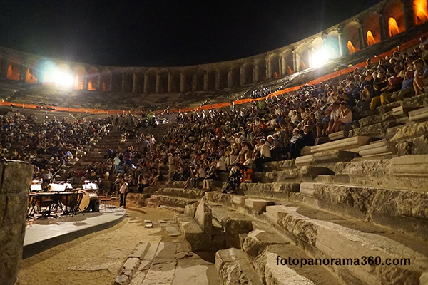
Aspendos is an ancient Roman city located near the Turkish Mediterranean coast about 35 km. east of Antalya. It features one of the best-preserved amphitheaters of antiquity, an acropolis and the remnants of a complex aqueduct system.

The acropolis - the highest part of the city - is located directly behind the amphitheater on a prominent hill. The ruins on the acropolis are close to the theater and can be accessed from the same parking lot on the path seen on the right side of the picture. 

http://fotopanorama360.com/aspendos/
The partially-excavated city complex is surrounded by agricultural fields. The view below looks toward the sea (south).
http://www.ritebook.in/2014/03/aspendos-roman-theater-turkey.html

The theater was built in 155 A.D. by a native of the city, the architect Zenon, during the rule of the Roman Emperor Marcus Aurelius. Consistent with the earlier Hellenistic (Greek) practice, the back side of the theater was built into the hill.
As one of the best-preserved ancient theaters in the ancient world, the Aspendos Theater has a diameter of 96 m. (380 feet), and provided seating for 15,000 people.

It was being refurbished when I was there in the Summer of 2014, and workers were installing a large roof over the perimeter of the structure. 


Compare the size of the workers walking on the new roof to the main structure - it is huge!


Cliff Emerson©
The sides of the amphitheater were built over vaulted arches. Post holes for 58 masts are found in the upper level of the theater. The masts supported a velarium (leather awning) that could be pulled over the top of the audience to provide shade.
Cliff Emerson©

The high stage served to isolate the audience from the rest of the population. The entire stone backdrop structure has remained intact. An 8-meter-wide wooden ceiling over the stage was used to reflect sound - it has been lost over time. In the 13th century, the Seljuks converted the stage building into a palace.

They repaired the theater from time to time, and also used it as a caravanserai - a place on a traveled path where the camels and caravan party members could stop overnight at a protective environment - and receive rest, water, and food. These are found throughout Turkey and parts of the Middle East. I will feature one in an upcoming post.
https://www.tripadvisor.com.tr/LocationPhotoDirectLink-g297963-d548067-i306099135-Aspendos_Ruins_and_Theater-Serik_Serik_District_Turkish_Mediterranean_Coa.html

Current Use of the Structure
Until recently, the ancient theater was used for concerts, festivals and other public events. Due to damage caused by theatrical and sound equipment, authorities decided to open a new, modern facility nearby and devote the amphitheater strictly to tourism. 

Below, a carved Dionysus figure from a stone gable in the stage structure. 
http://www.theatrum.de/703.html

Above: Aspendos, römisches Theater, Mittelgiebel in der scaenae frons mit Darstellung des aus dem Akanthusbusch wachsenden Dionysos (Photo: G. Krämmer).

Aspendos roman theater, center gable of the scaenae frons with a representation of Dionysios in the midst of the growing Akanthus bush.

For me, Aspendos was a mystical place - an impression I obtained from viewing the aqueduct ruins with a backdrop of curiously-shaped mountains to the west and north - set in a misty environment.

The aqueduct system supplied water to the ancient roman city from spring sources in the neighboring mountains to the west - over a distance of 19 km. This is the best part of the visit. It would have been extremely enjoyable to investigate the entire length of the water channel route beyond the stretch where the aqueduct crossed the valley, but time wouldn't allow, nor did I have adequate documentation or a map.

According to historians, there were two sources of spring water: the Gökçepinar (pleasant spring) at 550 m. elevation, with a discharge of 30-40 liters/sec and the Pinarbas (springhead) at 440 m., with a discharge of 40 liters/sec.

cliff_emerson
Above, a section of the Aspendos Aqueduct, as it curves roughly 50-degrees toward the acropolis hill. The water in the aqueduct came out of the mountains in the background, went through a siphon device to in order to cross the valley, and turned at the height you can see in the picture. It then proceeded across this +100 meter section into the city on the acropolis. (see map, below.)

Also above, in the foreground, huge pieces of concrete from the Roman city have fallen down the hillside and remain lying there.
The path of the lower section of the aqueduct is marked in yellow as it crosses the valley. 

To me, this is the most intriguing part of the Aspendos site. 

I will go into the details of the aqueduct in soon. Click here to connect with another post that discusses the aqueduct system.

cliff_emerson
A village with a mosque and minaret is located next to the aqueduct, looking southwest. In the background, are a few of those strange, mystical hills.

History
Aspendos was an ancient city in the region of Pamphylia, situated on the Eurymedon River, about 16 kilometres inland from the Mediterranean Sea. It had a hostile relationship with a neighboring city, Side (LINK), on the Mediterranean coast.

During the Bronze Age, the Hittites called the city Asitawanda, a place where they traded horses. Like nearby Perge, Aspendos was probably established many years earlier in the Iron Age.

Aspendos was one of the earliest cities to mint coins in the region, first came the "staters" and later, Greek drachmas.

The wide range of its coinage found throughout the ancient world indicates that by the 5th century B.C., Aspendos had become very influential urban center in Pamphylia. 
Aspendos continued to issue coins until the late Roman period.

At that time the nearby Eurymedon River was navigable as far as Aspendos, and the city derived great wealth from a trade in salt, oil, and wool. 

https://www.romeartlover.it/Aspendos.html

An attractive ceremonial arch was built over one of the three streets leading to the upper town. Archaeologists have found a limited number of statues, reliefs and in general marbles in the upper town (acropolis) of Aspendos, unlike the numerous finds at nearby Perge.

In 333 B.C., Aspendos paid a tribute to Alexander the Great to avoid being taken over. It later ignored its agreements with him, and was then occupied. In 190 B.C. the city surrendered to the Romans, who later pillaged its artistic treasures.   
Aspendos went into decline towards the end of the Roman period, which continued throughout the Byzantine times.

Scanned map.
The map above (I found it on-line years ago, but can't site it now), shows the destinations that I pursued with my rental car on that one hurried day: Side (right side), followed by Aspendos, and then Perge. Aspendos is located 48 km. east of Antalya.

Archaeology Insights:
Near the ancient theater stands the remains of several items: a basilica, an agora, a nymphaeum and a Roman aqueduct that extended 15 km. into the mountains. I may cover these in a future post.

The remains of an aqueduct siphon system at Aspendos are matched by another system located in Pergamon (modern Perga), Turkey. More forthcoming in a future blog.

The Roman Eurymedon Bridge, (greatly reconstructed) is also in the vicinity, and will be covered in a future post.


Click here for the Blog's Table of Contents


Friday, April 17, 2015

Tourist Attractions: Nemrut Dağı

Before I get back to my primary focus - western Turkey - I'd like to share photos of a special tourist site in the East.
http://www.roughguides.com/destinations/europe/turkey/things-miss/#/5
Nemrut Dagi (Turkish: Nemrut Dağı; Armenian: Նեմրութ լեռ), would probably be my favorite place to visit. However, due to the war in Syria, and unstable conditions in eastern Turkey, it was not recommended to visit in those days. A Westerner could get kidnapped, or worse. 

I chose to drive north to Hittite country (Hattusha) from my conference in Nevsehir, Cappadocia instead of a couple 100 km. to Nemrut Dağı in the east. YouTube video 9:01
https://www.youtube.com/watch?v=1ZCxBRA66u4

http://whc.unesco.org/uploads/thumbs/site_0448_0004-500-333-20140708161646.jpg
The ruins are located on a cone-shaped mountain. The Ataturk Reservoir on the Euphrates River is visible in the background (and also featured on maps at the end of this post.)


The archaeological site actually consists of two collections of stone heads and rubble on opposite sides of a the hill (elevation: 2,134 m / 7,001 ft) in a very remote area of East-central Turkey.
http://sacredsites.com/images/middle_east/turkey/strange-peak-500.jpg
The complexes - on opposite sides of the mountain - were erected by the ancient Armenian king, Antiochus, head of the Commagene Empire. These statues - along with fragments of bas-relief figures from a frieze - are located near the summit. 
http://www.roughguides.com/destinations/europe/turkey/things-miss/#/7
Damage to the statues indicates that they were intentionally decapitated; the heads now lie scattered throughout the site, and have not been restored to their original positions. Some are turned upright. The figures appear to have Greek-style facial features, but Persian clothing and hair-styling.

Archaeologists have created an historical reconstruction of this first-century BCE complex:  
www.adiyamantb.gov.tr -
A nearby site has a large stone slab with a lion, showing the arrangement of stars and the planets Jupiter, Mercury and Mars on 7 July 62 BC. The site is thought to have used for religious ceremonies based on the astronomical signs caused by alignment of specific figures.
http://www.otelcenneti.com/uploads/il/adiyaman.jpg
The Commagene Empire was a successor state to the Seleucid Empire, defeated by the Romans in 190 BCE at the Battle of Magnesia. LINK 
mhtpcakmak.blogcu.com
This religious site - between the Taurus mountains and the Euphrates - could have been created by Antiochus to unify his multi-ethnic kingdom and secure the authority of his dynasty.
http://whenonearth.net/beheaded-statues-nemrut-dagi-turkey/
Although the Imperial cult did not last long after Antiochus, several of his successors had their own tombs built on Mount Nemrud.
https://www.youtube.com/watch?v=7CG3VL-iRWE
The sites were excavated in 1881 by Karl Sester, a German engineer, who was scouting-out transport routes through the Ottoman Empire. Subsequent excavations have failed to reveal Antiochus' tomb, but he is still believed to be buried here.
http://whc.unesco.org/uploads/thumbs/site_0448_0002-500-333-20140708161645.jpg
Mount Nemrut was made a World Heritage site by UNESCO in 1987.


http://whenonearth.net/beheaded-statues-nemrut-dagi-turkey/
For around half of the year, Mount Nemrud lies covered in snow. Combined with freezing temperatures, this precipitation causes weathering or erosion of the statues.
whenonearth.net
Here's a helpful site map:
www.PlanetWare.com
Below, I've pinpointed the location of Nemrut Dağı, southeast of Malatya.
http://cromwell-intl.com/travel/turkey/pictures/map-physical.jpg
arpacik.net
GOOGLE.maps.com
Map above: Nemrut Dağı National Park, colored in green is near the Ataturk Reservoir on the Euphrates River. It drains to the SW on its way to meeting with the Tigris River in Iraq before pouring into the Persian Gulf.

Additional Information about Nemrut Dağı:
http://nemrud.nl/

Here is a link to the site's Table of Contents:  LINK
To visit other topics on my website, Click here for the Table of Contents

Featured Post

Hittites in Turkey #3 - Bogazköy

  wikipedia Hittite cuneiform tablets from Bogazköy  https://www.hethport.uni-wuerzburg.de/HPM/hpm-en.php?p=general-en The only existing col...